IMAGES TAKEN NEAR TO
Nettleton Hill, HUDDERSFIELD, HD7 4NZ
Introduction
This page details the photographs taken nearby to Nettleton Hill, HD7 4NZ by members of the Geograph project.
The Geograph project started in 2005 with the aim of publishing, organising and preserving representative images for every square kilometre of Great Britain, Ireland and the Isle of Man.

There are currently over 7.5m images from over14,400 individuals and you can help contribute to the project by visiting https://www.geograph.org.uk
Image Map
Images are licensed for reuse under creativecommons.org/licenses/by-sa/2.0
Notes
- Clicking on the map will re-center to the selected point.
- The higher the marker number, the further away the image location is from the centre of the postcode.
Image Listing (47 Images Found)
Images are licensed for reuse under creativecommons.org/licenses/by-sa/2.0
Image
Details
Distance
1
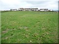
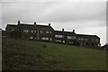
Green Edge
Most of the houses in this hamlet are on two roads - Green Lane Terrace and Nettleton Hill Road.
Image: © Christine Johnstone
Taken: 19 Apr 2015
0.00 miles

3

Moles Head (road), Nettleton Hill, Scapegoat Hill
Image: © Ian S
Taken: 27 Jul 2016
0.06 miles
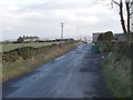
4
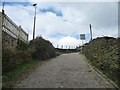
A road called Moleshead, climbing up Nettleton Hill
The only vehicle access to and from houses at the foot of the hill.
Image: © Christine Johnstone
Taken: 19 Apr 2015
0.06 miles
5
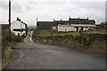
Nettleton Hill Road at Green Edge, Outlane
Looking towards the north side of the row of weavers cottagesImage at Green Edge, the setts in the road surface mark the top of the hairpin bends know as Mole's Head. The footpath to Hollin Hall goes through the gate on the right, but the sign board next to the gate is blank.
Image: © Richard Kay
Taken: 24 Nov 2009
0.06 miles
6
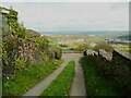
Lane to Heath Hill, Nettleton Hill, Longwood
Heath Hill is a house with a view. This is Huddersfield Footpath 431, which is supposed to turn left after going down a few steps beyond the end of the lane, however I could not find it.
Image: © Humphrey Bolton
Taken: 1 May 2023
0.08 miles

8
Green Edge, Outlane
From the number of large windows on the upper floor, it appears that these were formerly weavers cottages, where the maximum amount of light was needed for the work. This is the south-facing elevation.
Image: © Richard Kay
Taken: 24 Nov 2009
0.09 miles
9
Nettleton Hill Road - viewed from New Lane
Image: © Betty Longbottom
Taken: 8 Dec 2015
0.10 miles
