IMAGES TAKEN NEAR TO
HD6 9BP
Introduction
This page details the photographs taken nearby to HD6 9BP by members of the Geograph project.
The Geograph project started in 2005 with the aim of publishing, organising and preserving representative images for every square kilometre of Great Britain, Ireland and the Isle of Man.

There are currently over 7.5m images from over14,400 individuals and you can help contribute to the project by visiting https://www.geograph.org.uk
Image Map
Images are licensed for reuse under creativecommons.org/licenses/by-sa/2.0
Notes
- Clicking on the map will re-center to the selected point.
- The higher the marker number, the further away the image location is from the centre of the postcode.
Image Listing (326 Images Found)
Images are licensed for reuse under creativecommons.org/licenses/by-sa/2.0
Image
Details
Distance
1
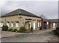
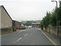
Building in former Dyeworks, Dyehouse Lane, Rastrick
This building must have been an office of the dyeworks or an employee's house . It is now the HQ of the Brighouse and Spen Bridge Club.
Image: © Humphrey Bolton
Taken: 8 Apr 2006
0.04 miles
2
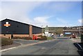
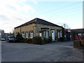
Royal Mail Sorting Office, Dyehouse Lane, Rastrick
Dyehouse Lane had been built by c.1895 to give better access to the Calder Dye Works, which was built before 1850 next to the Navigation towpath on the riverbank.
Image: © Humphrey Bolton
Taken: 8 Apr 2006
0.05 miles
3
Tree stumps in wall, Dyehouse Lane, Rastrick
Here gaps have been left in a stone wall for trees, which have since died.
Image: © Humphrey Bolton
Taken: 9 Apr 2006
0.05 miles
4
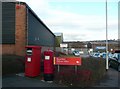
Letter boxes, Dyehouse Lane, Rastrick
Rastrick, with a population of c.12,000, must be one of the largest towns not to have a post office, but ironically it has the Brighouse Delivery Office. The two letter boxes are HD6 291, an EiiR pillar box, and HD6 318, a business box.
Image: © Humphrey Bolton
Taken: 22 Dec 2008
0.05 miles
7
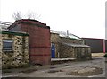
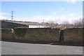
Chimney base, Calder Dye Works, Birds Royd, Rastrick
The dyeworks started before 1850 as the Calder Dye Works (Silk and Cotton). Now some of the buildings have been demolished, leaving a way through from Dyehouse Lane to Foundry Street. From this way the base of a red-brick factory chimney can be seen.
Image: © Humphrey Bolton
Taken: 8 Apr 2006
0.05 miles
8
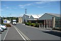
Siddal and Hilton, Foundry Street, Rastrick
They make steel wire fabrications including various types of fencing panels.
Image: © Humphrey Bolton
Taken: 16 Aug 2010
0.05 miles
9
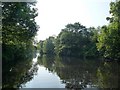
River Calder below Brighouse Locks
This section of the river is navigable.
Image: © Christine Johnstone
Taken: 22 May 2010
0.08 miles
10
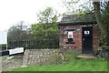
The Old Toll House at Ha'penny Bridge
Ha'penny Bridge was provided for boat men to cross the River Calder as they left Brighouse basin on their journey downstream towards Mirfield. The ramp up to the bridge can be seen on the left of the toll house. Sadly, the bridge no longer exists, but old prints are available.
Image: © Richard Kay
Taken: 3 May 2008
0.08 miles