IMAGES TAKEN NEAR TO
Jay House Lane, BRIGHOUSE, HD6 4JH
Introduction
This page details the photographs taken nearby to Jay House Lane, HD6 4JH by members of the Geograph project.
The Geograph project started in 2005 with the aim of publishing, organising and preserving representative images for every square kilometre of Great Britain, Ireland and the Isle of Man.

There are currently over 7.5m images from over14,400 individuals and you can help contribute to the project by visiting https://www.geograph.org.uk
Image Map
Images are licensed for reuse under creativecommons.org/licenses/by-sa/2.0
Notes
- Clicking on the map will re-center to the selected point.
- The higher the marker number, the further away the image location is from the centre of the postcode.
Image Listing (41 Images Found)
Images are licensed for reuse under creativecommons.org/licenses/by-sa/2.0
Image
Details
Distance
1
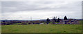
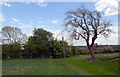
Houses on Clough Lane viewed across a field
Image: © habiloid
Taken: 4 Apr 2020
0.01 miles
2
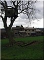
The Bront? Way
Cottages at Clough, northeast of Brighouse, looking south from the green lane section of Clough Lane on the Brontë Way.
Image: © Paul Glazzard
Taken: 25 Feb 2007
0.01 miles
3
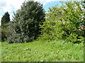
Brighouse FP72, Jay House Farm branch, at Clough, Clifton
The path should go between the hedge and the holly tree on the left, but the branches of the tree have blocked it.
Image: © Humphrey Bolton
Taken: 7 May 2015
0.02 miles
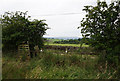
4
Brighouse FP72 approaching a footbridge
Looking towards the bridge in Image
Image: © Humphrey Bolton
Taken: 9 Apr 2015
0.03 miles
5
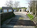
Cattle grid on Clough Lane
The driveway turns left to the houses called The Clough, and a branch of Brighouse FP72 goes that way to Jay House Lane. The other branch, formerly a continuation of Clough Lane, goes straight forward into the snicket shown in Image] and onwards to Birkhouse.
Image: © Humphrey Bolton
Taken: 9 Apr 2015
0.03 miles
7
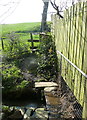
Brighouse FP72 crossing a stream
Rather a narrow bridge, but there is a handrail.
Image: © Humphrey Bolton
Taken: 9 Apr 2015
0.03 miles
8
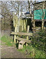
Stile on Brighouse FP72
Over the stile the path crosses a stream via a little stone slab bridge. The waymark pointing to the right is for Brighouse FP138 to Woolrow. This is shown on the Calderdale rights-of-way map and on the 1:50000 map, but not on the 1:25000 map.
Image: © Humphrey Bolton
Taken: 9 Apr 2015
0.03 miles
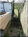
9
Path between Birkhouse Road and Clough Lane, Bailiff Bridge
Image: © habiloid
Taken: 9 May 2020
0.03 miles
