IMAGES TAKEN NEAR TO
Huddersfield Road, BRIGHOUSE, HD6 3TS
Introduction
This page details the photographs taken nearby to Huddersfield Road, HD6 3TS by members of the Geograph project.
The Geograph project started in 2005 with the aim of publishing, organising and preserving representative images for every square kilometre of Great Britain, Ireland and the Isle of Man.

There are currently over 7.5m images from over14,400 individuals and you can help contribute to the project by visiting https://www.geograph.org.uk
Image Map
Images are licensed for reuse under creativecommons.org/licenses/by-sa/2.0
Notes
- Clicking on the map will re-center to the selected point.
- The higher the marker number, the further away the image location is from the centre of the postcode.
Image Listing (122 Images Found)
Images are licensed for reuse under creativecommons.org/licenses/by-sa/2.0
Image
Details
Distance
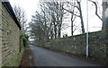
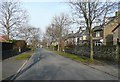
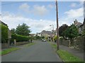
1
Long Fallas Crescent, off Woodhouse Lane, Rastrick
Not so much a crescent as two straights connected by a sharp bend.
Image: © Humphrey Bolton
Taken: 12 Sep 2007
0.02 miles
2
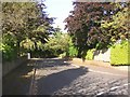
Somerset Avenue, off Woodhouse Lane, Rastrick
If this road carried on it would soon meet Huddersfield Road.
Image: © Humphrey Bolton
Taken: 12 Sep 2007
0.02 miles
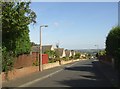
4
Lyndhurst Grove Road - Huddersfield Road
Image: © Betty Longbottom
Taken: 4 Jul 2009
0.05 miles
5
Solar panels, Somerset Avenue
Solar power on the roof of one of the bungalows that make up a large proportion of houses on this estate.
Image: © Stephen Craven
Taken: 5 Jul 2014
0.05 miles
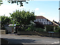
7
View from Shepherds Thorn Lane, Brighouse
Looking across a field to the backs of houses on Woodhouse Lane.
Image: © habiloid
Taken: 5 Feb 2022
0.05 miles
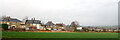
8
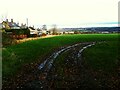
Part of the site for Brighouse Garden Suburb (SW corner)
This field may shortly become part of a proposed housing development called "Brighouse Garden Suburb" comprising 1257 properties on 62ha of land. Construction was planned to be phased from 2020-2033, although the 2020 Covid-19 pandemic seems to have delayed the start of construction.
Image: © Stephen Craven
Taken: 24 Dec 2020
0.06 miles
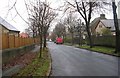
9
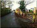
Shepherds Thorn Lane. looking west
The unassuming farm gateway here may shortly become the entrance to part of a proposed housing development called "Brighouse Garden Suburb" comprising 1257 properties on 62ha of land. Construction was planned to be phased from 2020-2033, although the 2020 Covid-19 pandemic seems to have delayed the start of construction. It's not clear how this narrow lane will cope with the additional construction traffic, or that of residents when properties are occupied. See also Image
Image: © Stephen Craven
Taken: 24 Dec 2020
0.07 miles