IMAGES TAKEN NEAR TO
Fletcher Crescent, BRIGHOUSE, HD6 3PR
Introduction
This page details the photographs taken nearby to Fletcher Crescent, HD6 3PR by members of the Geograph project.
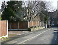
The Geograph project started in 2005 with the aim of publishing, organising and preserving representative images for every square kilometre of Great Britain, Ireland and the Isle of Man.

There are currently over 7.5m images from over14,400 individuals and you can help contribute to the project by visiting https://www.geograph.org.uk
Image Map
Images are licensed for reuse under creativecommons.org/licenses/by-sa/2.0
Notes
- Clicking on the map will re-center to the selected point.
- The higher the marker number, the further away the image location is from the centre of the postcode.
Image Listing (215 Images Found)
Images are licensed for reuse under creativecommons.org/licenses/by-sa/2.0
Image
Details
Distance
1
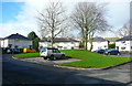
Fletcher Crescent, Rastrick
This housing estate was built in the mid-20C on a field called 'Fletcher Lands'. A very generous area was left in the middle so that many of the houses face a grassy 'island' with trees.
Image: © Humphrey Bolton
Taken: 28 Feb 2017
0.03 miles
2
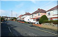
Houses, Garlick Street, Rastrick
The street is an extension of a short 19C street, and at the top it turns a right-angle and drops down to Slade Lane, built on a field called Long Croft.
Image: © Humphrey Bolton
Taken: 28 Feb 2017
0.03 miles
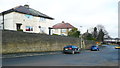
3
Houses above Slade Lane, Rastrick
These houses face Slade Lane but are separated from it by a retaining wall; they are part of the Fletcher Crescent estate.
Image: © Humphrey Bolton
Taken: 28 Feb 2017
0.03 miles
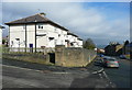
4
Houses above a retaining wall, Slade Lane. Rastrick
Presumably the road was widened when the housing estate was built. There is an arched entrance between the parked cars, leading to steps up to the houses.
Image: © Humphrey Bolton
Taken: 28 Feb 2017
0.04 miles
5
Garlick Street approaching Slade Lane, Rastrick
Modern OS maps suggest that there is a back lane behind the houses along the west side of Slade Lane, but this does not exist. The old-looking wall looks like an old field wall, but the field (Long Croft) boundary was alongside the stone-built house on the left, so the wall must have been built in the mid-20C when the road was made. There is a plot of land behind the wall and fence that nowadays would have had a house built on it, but at the time it was presumably considered to be too small.
Image: © Humphrey Bolton
Taken: 28 Feb 2017
0.04 miles
6
Fletcher Crescent, Slade Lane, Rastrick
This council housing estate, which includes houses on Clough Lane, was built in 1936-38 on a field called Fletcher Lands. Like some other estates of that period it is built around a small grassed area with trees.
Image: © Humphrey Bolton
Taken: 12 Jun 2006
0.04 miles
7
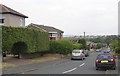
Greenhead Lane, Rastrick
This is the Slade lane end of the lane, which is not on the 1824 township map, but is shown running between fields on the 1850 OS map. However it was not extended to New Hey Road until the area was developed with terrace houses.
Image: © Humphrey Bolton
Taken: 12 Jun 2006
0.05 miles
8
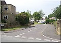
Carr Green Drive, Rastrick
This is the Slade Lane end, with a magnificent hedge with topiary archway on the left.
Image: © Humphrey Bolton
Taken: 12 Jun 2006
0.05 miles
9
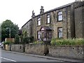
Two double-fronted houses in Slade Lane, Rastrick
As often around here, the houses are at a higher level than the road, and there were coal houses or cellars behind the retaining wall next to the road. The hatches into which the sacks of coal were emptied are generally blocked now and the iron cover removed, but here one cover survives.
Image: © Humphrey Bolton
Taken: 12 Jun 2006
0.05 miles
10
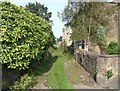
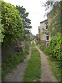
Greenhead Lane, off Slade Lane, Rastrick
See also Image Spot the sunflower in this new view of the lane! Notice also the rounded stone at the corner on the right, to protect the wall from carts turning into the lane.
Image: © Humphrey Bolton
Taken: 20 Sep 2008
0.05 miles