IMAGES TAKEN NEAR TO
Sherburn Road, BRIGHOUSE, HD6 3LJ
Introduction
This page details the photographs taken nearby to Sherburn Road, HD6 3LJ by members of the Geograph project.
The Geograph project started in 2005 with the aim of publishing, organising and preserving representative images for every square kilometre of Great Britain, Ireland and the Isle of Man.

There are currently over 7.5m images from over14,400 individuals and you can help contribute to the project by visiting https://www.geograph.org.uk
Image Map
Images are licensed for reuse under creativecommons.org/licenses/by-sa/2.0
Notes
- Clicking on the map will re-center to the selected point.
- The higher the marker number, the further away the image location is from the centre of the postcode.
Image Listing (123 Images Found)
Images are licensed for reuse under creativecommons.org/licenses/by-sa/2.0
Image
Details
Distance
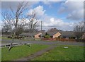
1
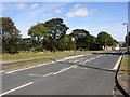
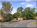
Sherburn Road, Rastrick
Sherburn Road is one of the main roads of the housing estate, and here comes up the hill parallel to the edge of the estate. It seems odd that there is a gap in the development on the left, especially as buildings are shown here on the 1:25 000 OS map.
Image: © Humphrey Bolton
Taken: 18 Sep 2007
0.02 miles
2
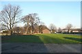
Site of buildings, Sherburn Road, Rastrick
There were four blocks here when the maps.live aerial photograph was taken, flats or houses, and some more on nearby sites that are now open grass areas. Why were they demolished?
Image: © Humphrey Bolton
Taken: 6 Jan 2009
0.02 miles
3
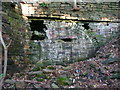
Arch in retaining wall and cavity under Boothroyd Lane, Rastrick
This looks rather alarming. I will come back with a torch sometime to see what is supporting the road. Old 1:2500 maps show what appears to be a quarry face on the other side of the road, so perhaps there was a way to it under the road from the main quarries on this side.
Image: © Humphrey Bolton
Taken: 28 Sep 2015
0.04 miles
4
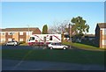
Mobile library at Wensley Grove, Field Lane Estate, Rastrick
Parked in a quiet cul-de-sac.
Image: © Humphrey Bolton
Taken: 6 Jan 2009
0.04 miles
5
Arncliffe Drive, Rastrick
Seen from the grassed area stretching down from Malham Road.
Image: © Humphrey Bolton
Taken: 6 Mar 2009
0.04 miles
6
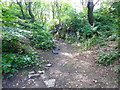
Public footpath on a quarry track through a rock cutting, Strangstry Wood
This is on the boundary between Rastrick and Elland.
Image: © Humphrey Bolton
Taken: 7 Sep 2015
0.05 miles
7
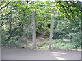
Stile on Brighouse FP122 at Boothroyd Lane, Rastrick
There is a flight of steps on the other side of the stile. The path leads to various paths in Strangstry Wood.
Image: © Humphrey Bolton
Taken: 7 Sep 2015
0.05 miles
8
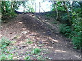
Steps down from Boothroyd Lane, Rastrick
These are the steps that you go down after going through the stile from the road (see Image]).
Image: © Humphrey Bolton
Taken: 7 Sep 2015
0.05 miles
9
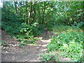
Brighouse FP85 in Strangstry Wood, Rastrick
This path goes along a quarried trench (Harry Hill Quarry) close to the township boundary. There is a much more attractive path on the ridge (Harry Hill) to the left.
Image: © Humphrey Bolton
Taken: 7 Sep 2015
0.05 miles
10
Sherburn Road, Rastrick
Sherburn Road is one of the main roads of the housing estate, and comes up the hill parallel to the edge of the estate and here turns to run parallel to Lower Edge Road.
Image: © Humphrey Bolton
Taken: 18 Sep 2007
0.06 miles