IMAGES TAKEN NEAR TO
Sherburn Road, BRIGHOUSE, HD6 3JH
Introduction
This page details the photographs taken nearby to Sherburn Road, HD6 3JH by members of the Geograph project.
The Geograph project started in 2005 with the aim of publishing, organising and preserving representative images for every square kilometre of Great Britain, Ireland and the Isle of Man.

There are currently over 7.5m images from over14,400 individuals and you can help contribute to the project by visiting https://www.geograph.org.uk
Image Map
Images are licensed for reuse under creativecommons.org/licenses/by-sa/2.0
Notes
- Clicking on the map will re-center to the selected point.
- The higher the marker number, the further away the image location is from the centre of the postcode.
Image Listing (107 Images Found)
Images are licensed for reuse under creativecommons.org/licenses/by-sa/2.0
Image
Details
Distance
1
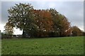
Trees in Autumnal Leaf near William Henry Smith School
Image: © Chris Heaton
Taken: 7 Nov 2023
0.02 miles
2
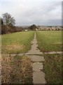
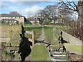
Path at Boothroyd, Rastrick, Yorkshire
This is an old path, formerly enclosed that runs from Boothroyd Lane down to Longroyde, heading for Rastrick Bridge. It is paved with stone flags, and the path that crosses in the foreground is also paved. The grass is gradually growing over the flags, giving an irregular zigzag effect. The path to the left goes to Boothroyd, now a private school, and the one to the right to a housing estate, although it was originally a field path to Field Lane.
Image: © Humphrey Bolton
Taken: 16 Feb 2006
0.03 miles
3
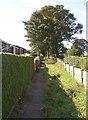
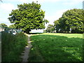
Path behind the houses, Sherburn Road, Rastrick
Between the back gardens and the field there is a footpath.
Image: © Humphrey Bolton
Taken: 18 Sep 2007
0.03 miles
4
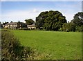
Brighouse Close, Rastrick
This field was called Upper and Lower Brighouse Close (now one field). An old flagged footpath runs down the field (shown in another photograph). The buildings are part of the William Henry Smith School. Of these, the older building hiding behind trees is Boothroyd, a mill-owner's house that became an orphanage.
Image: © Humphrey Bolton
Taken: 18 Sep 2007
0.03 miles
5
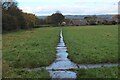
Path and stile near Boothroyd, Rastrick
The path and stile have been here since before 1850, although the stonework has probably been rebuilt since then.
Image: © Humphrey Bolton
Taken: 6 Mar 2009
0.03 miles
6
Ascot Grove, Rastrick
A short cul-de-sac off the lower part of Sherburn Road.
Image: © Humphrey Bolton
Taken: 18 Sep 2007
0.04 miles
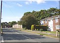
7

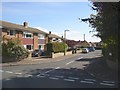
Sherburn Road, Rastrick
Here Sherburn Road sweeps round to the Highfield Road shops (behind the camera).
Image: © Humphrey Bolton
Taken: 18 Sep 2007
0.04 miles
8
Brighouse FP86 passing Boothroyd, Rastrick
The William Henry Smith School at Boothroyd is a non-maintained residential special school providing education and care for boys with social, emotional and behavioural difficulties.
Image: © Humphrey Bolton
Taken: 7 Sep 2015
0.06 miles
9
Footpath heading towards Rastrick
Flagged public footpath outside the grounds of William Henry Smith School
Image: © Chris Heaton
Taken: 7 Nov 2023
0.06 miles
10
Sherburn Road, Rastrick
This road runs parallel with the edge of the estate, behind the blocks of flats on the right. The road passes through a field that was called Wiggin Royd.
Image: © Humphrey Bolton
Taken: 18 Sep 2007
0.06 miles