IMAGES TAKEN NEAR TO
Castle Place, BRIGHOUSE, HD6 3HP
Introduction
This page details the photographs taken nearby to Castle Place, HD6 3HP by members of the Geograph project.
The Geograph project started in 2005 with the aim of publishing, organising and preserving representative images for every square kilometre of Great Britain, Ireland and the Isle of Man.

There are currently over 7.5m images from over14,400 individuals and you can help contribute to the project by visiting https://www.geograph.org.uk
Image Map
Images are licensed for reuse under creativecommons.org/licenses/by-sa/2.0
Notes
- Clicking on the map will re-center to the selected point.
- The higher the marker number, the further away the image location is from the centre of the postcode.
Image Listing (236 Images Found)
Images are licensed for reuse under creativecommons.org/licenses/by-sa/2.0
Image
Details
Distance
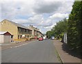
1
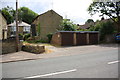
Castle Place Garages, Thornhill Road
Image: © Roger Templeman
Taken: 18 Jul 2018
0.02 miles
2
Brook Grain Hill, Rastrick
This is looking down the hill from Thornhill Road (A643). In the 19C there were Public Baths down the lane. They were stone troughs covered by a shelter and were set up by public subscription in 1783. The house on the left has the date 1912 carved on the stone lintel over the door.
Image: © Humphrey Bolton
Taken: 27 Feb 2006
0.02 miles
3
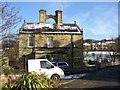
House with cat, Brook Grain Hill, Rastrick
This house has an unusual arch connecting two chimneys, and on the arch is a sculptured cat.
Image: © Humphrey Bolton
Taken: 4 Mar 2006
0.02 miles
4
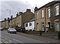
Cottages, Thornhill Road, Rastrick (SE139218)
Here there is a great contrast between the old cottages and the later 19C terrace houses. The cottages are on the township map of 1812, and were on what was then Brook Grain Hill. The surface of this was evidently at a lower level than the present road.
Image: © Humphrey Bolton
Taken: 27 Feb 2006
0.04 miles
5
Castlefields Drive, Rastrick
This road follows the valley, whilst Thornhill Road climbs steeply up to the town centre. The development started with the terrace houses on the right, and the road was made in the first half of the 20C. It gives access to the Castlefields Crescent estate, but the frontage development on the left is quite recent.
Image: © Humphrey Bolton
Taken: 22 Jul 2007
0.04 miles
6
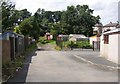
Garages off Castlefields Drive, Rastrick
I suspect that the newer concrete garages on the right belong to the recent terrace houses on Castlefields Drive. The garages beyond are casually placed amongst mown grass and trees, giving a pleasant impression.
Image: © Humphrey Bolton
Taken: 22 Jul 2007
0.04 miles
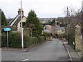
7
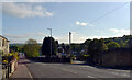
The junction of Thornhill Road (A643) and Brook Grain Hill, Rastrick
Image: © habiloid
Taken: 7 May 2022
0.05 miles
8

Castle Hill Golf Course, Rastrick
This is a private six-hole course in a very secluded position on the Castle Hill estate. This view is looking south-westwards towards Rastrick Independent School.
Image: © Humphrey Bolton
Taken: 17 Dec 2005
0.06 miles
9
Lodge and house, Rastrick Common, Rastrick
The Lodge was for Castle Hill House, on Thornhill Road to the north. The lodge is here because Rastrick Common was the main road and there was only a narrow lane where Thornhill Road is now.
Image: © Humphrey Bolton
Taken: 8 Apr 2006
0.06 miles
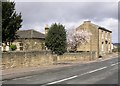
10

Terrace houses, Rastrick Common, Rastrick
I noticed for the first time the window in the gable, shaped like three overlapping circles.
Image: © Humphrey Bolton
Taken: 22 Dec 2008
0.06 miles