IMAGES TAKEN NEAR TO
Rosemary Place, BRIGHOUSE, HD6 3EJ
Introduction
This page details the photographs taken nearby to Rosemary Place, HD6 3EJ by members of the Geograph project.
The Geograph project started in 2005 with the aim of publishing, organising and preserving representative images for every square kilometre of Great Britain, Ireland and the Isle of Man.

There are currently over 7.5m images from over14,400 individuals and you can help contribute to the project by visiting https://www.geograph.org.uk
Image Map
Images are licensed for reuse under creativecommons.org/licenses/by-sa/2.0
Notes
- Clicking on the map will re-center to the selected point.
- The higher the marker number, the further away the image location is from the centre of the postcode.
Image Listing (173 Images Found)
Images are licensed for reuse under creativecommons.org/licenses/by-sa/2.0
Image
Details
Distance
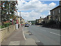
1
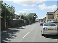
Rastrick Common - viewed from Rosemary Lane
Image: © Betty Longbottom
Taken: 30 Jul 2013
0.01 miles
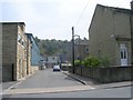
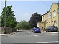
5
Rastrick Common - viewed from Rosemary Lane
Image: © Betty Longbottom
Taken: 30 Jul 2013
0.04 miles
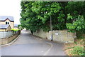
7
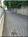
Rastrick - cobbles on Rosemary Lane
For an alternative view, please see Image
Image: © Dave Bevis
Taken: 1 Sep 2012
0.05 miles
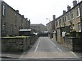
8
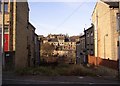
Eleanor Street, Rastrick
Taken from Brook Street, looking towards Bramston Street. The western part of Eleanor Street is unmade to the extent of being overgrown! However the point of the photo is the houses above Bramston Street in the distance, which rise up the steep hillside in tiers. See also photo of Capel Street.
Image: © Humphrey Bolton
Taken: 17 Dec 2005
0.05 miles
9
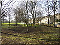
Recreation Ground, Bramston Street, Rastrick
This land was previously used as a rubbish tip, which was full by 1911. The street was widened at that time, and became the A643 later in the 20C. There is an attractive circular shelter and a basketball playing area.
Image: © Humphrey Bolton
Taken: 21 Jan 2006
0.05 miles
10
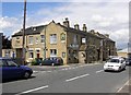
The White Horse, Rastrick Common
This pub dates back to the days when this was a turnpike road, and later an 'A' class road.
Image: © Humphrey Bolton
Taken: 16 Jul 2007
0.05 miles