IMAGES TAKEN NEAR TO
Springvale Works, Elland Road, BRIGHOUSE, HD6 2RN
Introduction
This page details the photographs taken nearby to Springvale Works, Elland Road, HD6 2RN by members of the Geograph project.
The Geograph project started in 2005 with the aim of publishing, organising and preserving representative images for every square kilometre of Great Britain, Ireland and the Isle of Man.

There are currently over 7.5m images from over14,400 individuals and you can help contribute to the project by visiting https://www.geograph.org.uk
Image Map
Images are licensed for reuse under creativecommons.org/licenses/by-sa/2.0
Notes
- Clicking on the map will re-center to the selected point.
- The higher the marker number, the further away the image location is from the centre of the postcode.
Image Listing (100 Images Found)
Images are licensed for reuse under creativecommons.org/licenses/by-sa/2.0
Image
Details
Distance
1
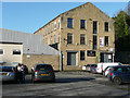
The former Slead Sike Mill, Brighouse
This is shown as a woollen mill on the 1850 six-inch map, and as Slead Mill (Cloth Finishing) on the 1907 1:2500 map. Now it is part of Springvale Works.
Image: © Humphrey Bolton
Taken: 9 Dec 2019
0.02 miles
2
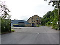
Brookfoot Business Park, Brighouse
Image: © Alexander P Kapp
Taken: 15 Jul 2010
0.03 miles
3
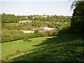
View of the Red Beck valley, Southowram
Taken from South Holme Lane. The Valley Dye Works and the far side of the valley are in Brighouse. The row of houses is along Clog Sole Road.
Image: © Humphrey Bolton
Taken: 28 Apr 2007
0.04 miles
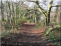
4
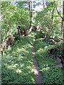
Footpath off Wood Bottom Lane (1)
The path is at first walled on both sides, with smallholdings on the left (east) side and woodland on the right.
Image: © Humphrey Bolton
Taken: 28 Apr 2007
0.04 miles
5
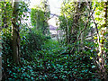
Former lane to Slead Sike Mill (Woollen), Brighouse
The lane can still be followed but there is a wall across it before the present Springfield Works is reached. Presumably the ivy prevents the growth of brambles. The lane is still captioned 'Mill Hill Lane' on the large-scale OS map.
Image: © Humphrey Bolton
Taken: 9 Dec 2019
0.04 miles
6
Path from the Brookfoot Business Park to Mill Hill Lane, Brighouse
Image: © Humphrey Bolton
Taken: 9 Dec 2019
0.04 miles
7
The lower part of Mill Hill Lane, Brighouse
This led to Slead Sike Mill. It is now a path that turns left down to the Brookfoot Business Park.
Image: © Humphrey Bolton
Taken: 9 Dec 2019
0.06 miles
8
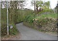
Wood Bottom Lane - Halifax Road, Hove Edge
Image: © Betty Longbottom
Taken: 3 May 2008
0.09 miles
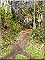
9
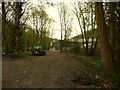
New track through woodland to Slead Mill, Brighouse
This gives a better access to Wet Shod Lane, via the industrial estate and Slead Mill yard. There was originally a footpath on this line, but it is now a little further to the north-east.
Image: © Humphrey Bolton
Taken: 2 May 2022
0.10 miles
10
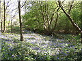
Bluebells off Wetshod Lane, Brighouse
This is relatively new woodland on an area shown as a tip on a mid-20C map and as a field in 1850, but has a dense display of bluebells.
Image: © Humphrey Bolton
Taken: 28 Apr 2007
0.10 miles