IMAGES TAKEN NEAR TO
Dyson Street, BRIGHOUSE, HD6 2DN
Introduction
This page details the photographs taken nearby to Dyson Street, HD6 2DN by members of the Geograph project.
The Geograph project started in 2005 with the aim of publishing, organising and preserving representative images for every square kilometre of Great Britain, Ireland and the Isle of Man.

There are currently over 7.5m images from over14,400 individuals and you can help contribute to the project by visiting https://www.geograph.org.uk
Image Map
Images are licensed for reuse under creativecommons.org/licenses/by-sa/2.0
Notes
- Clicking on the map will re-center to the selected point.
- The higher the marker number, the further away the image location is from the centre of the postcode.
Image Listing (239 Images Found)
Images are licensed for reuse under creativecommons.org/licenses/by-sa/2.0
Image
Details
Distance
1
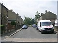
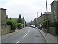
Catherine Street - Lightcliffe Road
Image: © Betty Longbottom
Taken: 27 Jun 2009
0.03 miles
4
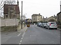
William Henry Street - Lightcliffe Road
Image: © Betty Longbottom
Taken: 27 Jun 2009
0.03 miles
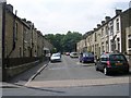
6
Garden Road - viewed from Blackburn Road
Image: © Betty Longbottom
Taken: 7 Apr 2013
0.04 miles
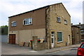
7
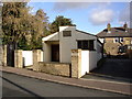
Chapel of Rest, Lightcliffe Road, Brighouse
This belongs to a Funeral Director in Spring Gardens.
Image: © Humphrey Bolton
Taken: 21 Nov 2006
0.05 miles
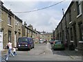
8
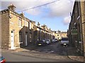
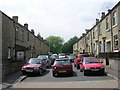
William Henry Street, Brighouse
Although part of the late 19C street layout, this street has in it a row of 18C cottages, identified by their lower roof-line. They are Grade II listed, and have the stone doorway surrounds and flat-faced mullioned windows typical of the period in this area. For some reason the street has not been 'made-up' and surfaced with tarmac.
Image: © Humphrey Bolton
Taken: 21 Nov 2006
0.05 miles
10
Weathered benchmark on #61 Lightcliffe Road (Garden Road face)
The Ordnance Survey cut mark benchmark on the 5th/6th stones above ground is described on the Bench Mark Database at www.bench-marks.org.uk/bm49296
Image: © Roger Templeman
Taken: 27 Jul 2018
0.05 miles