IMAGES TAKEN NEAR TO
Mill Lane, BRIGHOUSE, HD6 1PN
Introduction
This page details the photographs taken nearby to Mill Lane, HD6 1PN by members of the Geograph project.
The Geograph project started in 2005 with the aim of publishing, organising and preserving representative images for every square kilometre of Great Britain, Ireland and the Isle of Man.

There are currently over 7.5m images from over14,400 individuals and you can help contribute to the project by visiting https://www.geograph.org.uk
Image Map
Images are licensed for reuse under creativecommons.org/licenses/by-sa/2.0
Notes
- Clicking on the map will re-center to the selected point.
- The higher the marker number, the further away the image location is from the centre of the postcode.
Image Listing (647 Images Found)
Images are licensed for reuse under creativecommons.org/licenses/by-sa/2.0
Image
Details
Distance
1
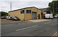
Motorcycle garage at Mill Lane / Karen's Way junction
Image: © Roger Templeman
Taken: 24 Jul 2018
0.01 miles
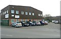
2
My Tribe Dance Studio, Mill Lane, Brighouse
This is the premises of the Empire Dance Troop school.
Image: © Humphrey Bolton
Taken: 9 Feb 2023
0.01 miles
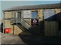
3
Dale House, Mill Lane, Brighouse
Crossling Plumbing and Pipework Merchants. One of the buildings on the old gas works site. The vehicle access to the canal basin is along the stone setted road to the right.
Image: © Humphrey Bolton
Taken: 16 Mar 2009
0.02 miles
4
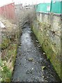
Clifton Beck downstream of Mill Lane
This forms the boundary between Brighouse and Clifton. Brighouse gas works was on the right (the part next to the beck is now a scrapyard).
Image: © Humphrey Bolton
Taken: 16 Mar 2009
0.02 miles
5
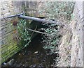
Clifton Beck culvert
The beck emerges from a 100m long stone culvert along and across Armytage Road and Mill Lane. The stone arch was possibly originally a bridge, as the mineral tramway from Low Moor crossed the beck here on its way down to the canal basin.
Image: © Humphrey Bolton
Taken: 2 Mar 2009
0.02 miles
6
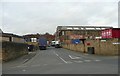
Grove Street, Clifton
An industrial street connecting Wakefield Road with Mill Lane, where it changes its name to Armytage Road. Grove Street Mills (Cotton in 1907) were on the right; one building survives.
Image: © Humphrey Bolton
Taken: 2 Mar 2009
0.02 miles
7
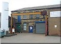
Kirklees Steel Works, Grove Street, Clifton
Updated from the 'Kirklees Iron Works' name in 1907, and the crane has been changed to a 12 ton gantry. The tank of liquid nitrogen would have surprised the Edwardians.
Image: © Humphrey Bolton
Taken: 16 Mar 2009
0.02 miles
8
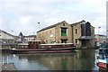
Boatyard in Brighouse Basin
The Sagar Marine Boatyard is operated from the stone warehouses, whose gable ends face the canal basin. The barge in front is a broad beam craft, built at the yard to dimensions similar to those of the old coal barges which used to be a common sight on the waterway.
Image: © Richard Kay
Taken: 28 Feb 2008
0.03 miles
9
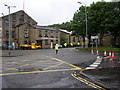
Road closed, Brighouse
This is the normally busy roundabout where Clifton Road and Wakefield Road meet. It has been closed due either to the risk of sudden flooding from Clifton Beck if the waterway of the bridge were to completely fill, or possibly the risk that the bridge might collapse. I wasn't allowed any closer to find out!
Image: © Humphrey Bolton
Taken: 25 Jun 2007
0.04 miles
10
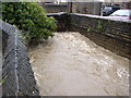
Clifton Beck in spate, Brighouse
This is the open section to the south of Wakefield Road, looking upstream. The waterway of the bridge is almost full. If it filled completely the additional friction of water against the top surface could cause a sudden increase in water level upstream.
Image: © Humphrey Bolton
Taken: 25 Jun 2007
0.04 miles