IMAGES TAKEN NEAR TO
Leeds Road, HUDDERSFIELD, HD5 0RL
Introduction
This page details the photographs taken nearby to Leeds Road, HD5 0RL by members of the Geograph project.
The Geograph project started in 2005 with the aim of publishing, organising and preserving representative images for every square kilometre of Great Britain, Ireland and the Isle of Man.

There are currently over 7.5m images from over14,400 individuals and you can help contribute to the project by visiting https://www.geograph.org.uk
Image Map
Images are licensed for reuse under creativecommons.org/licenses/by-sa/2.0
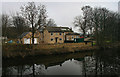
Notes
- Clicking on the map will re-center to the selected point.
- The higher the marker number, the further away the image location is from the centre of the postcode.
Image Listing (116 Images Found)
Images are licensed for reuse under creativecommons.org/licenses/by-sa/2.0
Image
Details
Distance
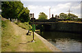
1
Cooper Bridge
Looking across the River Calder to Cooper Bridge.
Image: © Peter McDermott
Taken: 6 Jan 2013
0.00 miles
2
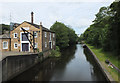
Calder And Hebble Navigation seen from Cooper Bridge Road
Image: © habiloid
Taken: 6 Jul 2019
0.02 miles
3
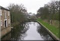
Calder & Hebble Navigation - Cooper Bridge Road
Image: © Betty Longbottom
Taken: 9 Apr 2008
0.03 miles
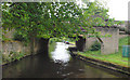
4
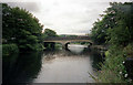
Cooper Bridge, River Calder
This is the bridge over the main river, with the weir ahead. Any craft going downstream through this bridge must turn right into the first lock of the Huddersfield Broad Canal.
Image: © Dr Neil Clifton
Taken: 25 Jul 1996
0.03 miles
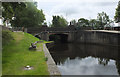
5
Cooper Bridge (over lock cut), Calder and Hebble Navigation
The 'real' Cooper Bridge spans the main river and is about 50 yards south-west along the A62. This much smaller bridge is across the navigable lock-cut. There was once a water-bus service here but it was not successful and was withdrawn.
Image: © Dr Neil Clifton
Taken: 25 Jul 1996
0.03 miles
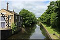
6
Leeds Road Bridge 22
Calder and Hebble Canal - carries A6107 across canal
Image: © Mike Todd
Taken: 18 Jun 2011
0.03 miles
7
Cooper Bridge, Calder And Hebble Navigation
Image: © habiloid
Taken: 6 Jul 2019
0.03 miles
8
River Calder looking Upstream from Cooper Bridge
The chimney belongs to the old Fearnley Textile Mill, now converted into flats.
Image: © Chris Heaton
Taken: 29 May 2022
0.03 miles
9
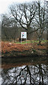
Calder and Hebble Navigation
Sign on the Calder and Hebble Navigation Canal.
Image: © Peter McDermott
Taken: 6 Jan 2013
0.03 miles
10
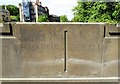
Old Boundary Marker by the A62, Cooper Bridge, Huddersfield
Municipal Boundary Marker by the A62, in parish of Huddersfield (Kirklees District), Cooper Bridge, River Calder, carved in NW parapet of bridge.
Inscription reads:- : HUDDERSFIELD / 19 : : W.R.C.C. / 38 :
Surveyed
Milestone Society National ID: YW_HUDWRY01pb.
Image: © Milestone Society
Taken: Unknown
0.03 miles