IMAGES TAKEN NEAR TO
Roslyn Avenue, HUDDERSFIELD, HD4 7EW
Introduction
This page details the photographs taken nearby to Roslyn Avenue, HD4 7EW by members of the Geograph project.
The Geograph project started in 2005 with the aim of publishing, organising and preserving representative images for every square kilometre of Great Britain, Ireland and the Isle of Man.

There are currently over 7.5m images from over14,400 individuals and you can help contribute to the project by visiting https://www.geograph.org.uk
Image Map
Images are licensed for reuse under creativecommons.org/licenses/by-sa/2.0
Notes
- Clicking on the map will re-center to the selected point.
- The higher the marker number, the further away the image location is from the centre of the postcode.
Image Listing (86 Images Found)
Images are licensed for reuse under creativecommons.org/licenses/by-sa/2.0
Image
Details
Distance
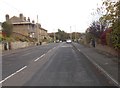
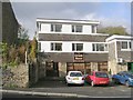
1
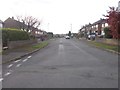
Roslyn Avenue - viewed from Deyne Road
Image: © Betty Longbottom
Taken: 2 Nov 2016
0.04 miles
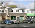
2
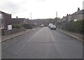
Henry Frederick Street - Roslyn Avenue
Image: © Betty Longbottom
Taken: 2 Nov 2016
0.05 miles
5
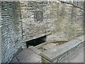
Netherton Well, South Crosland
As often, this well is by the roadside at the foot of a retaining wall. For the plaque see Image
Image: © Humphrey Bolton
Taken: 11 Jun 2009
0.08 miles
6
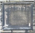
Plaque on Netherton Well, South Crosland
Is 'damageing' a mistake or the way that the word was spelt in the 19C?
Image: © Humphrey Bolton
Taken: 11 Jun 2009
0.08 miles
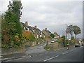
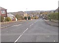
9
Netherton Dental Practice - Meltham Road
Image: © Betty Longbottom
Taken: 1 Nov 2010
0.10 miles