IMAGES TAKEN NEAR TO
South Crosland, HUDDERSFIELD, HD4 7BZ
Introduction
This page details the photographs taken nearby to HD4 7BZ by members of the Geograph project.
The Geograph project started in 2005 with the aim of publishing, organising and preserving representative images for every square kilometre of Great Britain, Ireland and the Isle of Man.

There are currently over 7.5m images from over14,400 individuals and you can help contribute to the project by visiting https://www.geograph.org.uk
Image Map
Images are licensed for reuse under creativecommons.org/licenses/by-sa/2.0
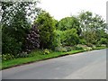
Notes
- Clicking on the map will re-center to the selected point.
- The higher the marker number, the further away the image location is from the centre of the postcode.
Image Listing (23 Images Found)
Images are licensed for reuse under creativecommons.org/licenses/by-sa/2.0
Image
Details
Distance
1
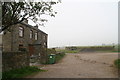
Misty September morning on the track past Hadden Farm
Image: © Chris
Taken: 11 Sep 2014
0.07 miles
2
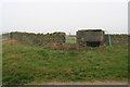
Stone water tank and trough opposite Hadden Farm
Image: © Chris
Taken: 11 Sep 2014
0.07 miles
3
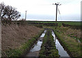
Turbid Lane, South Crosland
This is a short, muddy byway heading southeast from Intake Lane through farmland. It links up with other byways/farm roads before emerging in South Crosland village. A great adventure if you like mud.
Image: © michael ely
Taken: 3 Apr 2008
0.13 miles
4
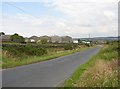
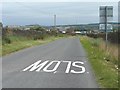
Intake Lane, South Crosland
Part of the route from Blackmoorfoot to South Crosland village. Moor End Farm is on the left.
Image: © Humphrey Bolton
Taken: 19 Jul 2007
0.14 miles
5
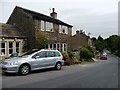
Stony Batter from the west
Just a few stone-built houses on School Hill.
Image: © Christine Johnstone
Taken: 28 Jun 2011
0.15 miles
6
Houses in the middle of Stony Batter
Once a row of four identical houses, but not any more.
Image: © Christine Johnstone
Taken: 28 Jun 2011
0.16 miles
7
Intake Lane, looking east
'Intake' refers to moorland converted to agriculture, often in the early 1800s. Hence MoorEnd Farm at the bend.
Image: © Christine Johnstone
Taken: 28 Jun 2011
0.16 miles
8
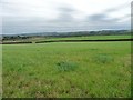
Grassland south of Intake Lane
Only 5 kms from the centre of Huddersfield, but 135 metres higher. In West Yorkshire you tend to go up to the countryside.
Image: © Christine Johnstone
Taken: 28 Jun 2011
0.17 miles
9
'Front gardens', Stony Batter [2]
Actually on the opposite side of the road to the houses.
Image: © Christine Johnstone
Taken: 28 Jun 2011
0.17 miles
10
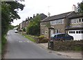
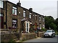
Stony Batter, School Hill, South Crosland
A row of houses at the north-western end of South Crosland village. The cottage in the foreground has weaver's windows - long and with many small lights with stone mullions between.
Image: © Humphrey Bolton
Taken: 19 Jul 2007
0.18 miles