IMAGES TAKEN NEAR TO
Manor Road/Tofts Lane, Manor Road, HUDDERSFIELD, HD4 6UL
Introduction
This page details the photographs taken nearby to Manor Road/Tofts Lane, Manor Road, HD4 6UL by members of the Geograph project.
The Geograph project started in 2005 with the aim of publishing, organising and preserving representative images for every square kilometre of Great Britain, Ireland and the Isle of Man.

There are currently over 7.5m images from over14,400 individuals and you can help contribute to the project by visiting https://www.geograph.org.uk
Image Map
Images are licensed for reuse under creativecommons.org/licenses/by-sa/2.0
Notes
- Clicking on the map will re-center to the selected point.
- The higher the marker number, the further away the image location is from the centre of the postcode.
Image Listing (12 Images Found)
Images are licensed for reuse under creativecommons.org/licenses/by-sa/2.0
Image
Details
Distance
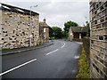
1
Manor Lane
The signpost points along the bridleway.
Image: © SMJ
Taken: 10 Aug 2008
0.03 miles
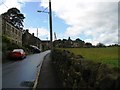
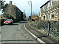
3
Manor Road, Netherton, Farnley Tyas, Yorkshire
This is the lower end of the road. The house on the right is one of several new houses, possibly replacing an old cottage or farm building. Emley Mast is framed by telephone poles.
Image: © Humphrey Bolton
Taken: 8 Feb 2006
0.11 miles
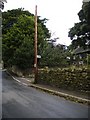
5
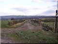
Tofts Lane, Farnley Tyas, Yorkshire
This short bridleway links Field Lane with Manor Road. Unfortunately there is a large puddle on the corner! On the horizon we see Emley Mast yet again. The old sign fastened to the bridleway signpost points to Clay Pigeon Shooting down Field Lane.
Image: © Humphrey Bolton
Taken: 9 Feb 2006
0.16 miles

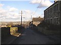
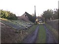
7
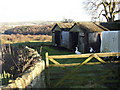
Sheds at the end of Manor Road, Netherton, Farnley Tyas, Yorkshire
The road ends abruptly here, and the land drops away steeply into the valley of Range Dike.
Image: © Humphrey Bolton
Taken: 8 Feb 2006
0.17 miles
8
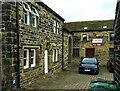
Woodview Farmhouse and Farnley House, Netherton, Farnley Tyas
This is a revisit to the first geograph of the square: Image], taken in October 2005. The building on the right is part of what is captioned 'Farnley House' on the large-scale map on the Historic England map search site, and is currently for sale. Quoting from Bramley's website "The property has historically been used as the Farnley Estate office and has recently been granted planning consent for conversion into a single residential dwelling."
Image: © Humphrey Bolton
Taken: 28 Oct 2021
0.17 miles
9
Old roof at Netherton, Farnley Tyas, Yorkshire
This belongs to a farm building at a lower level on the left, and is looking southwards on Mill Lane, which turned out to be a private track and not the footpath that I was looking for.
Image: © Humphrey Bolton
Taken: 8 Feb 2006
0.19 miles