IMAGES TAKEN NEAR TO
Quarry Road, HUDDERSFIELD, HD4 5PA
Introduction
This page details the photographs taken nearby to Quarry Road, HD4 5PA by members of the Geograph project.
The Geograph project started in 2005 with the aim of publishing, organising and preserving representative images for every square kilometre of Great Britain, Ireland and the Isle of Man.

There are currently over 7.5m images from over14,400 individuals and you can help contribute to the project by visiting https://www.geograph.org.uk
Image Map
Images are licensed for reuse under creativecommons.org/licenses/by-sa/2.0
Notes
- Clicking on the map will re-center to the selected point.
- The higher the marker number, the further away the image location is from the centre of the postcode.
Image Listing (9 Images Found)
Images are licensed for reuse under creativecommons.org/licenses/by-sa/2.0
Image
Details
Distance
2
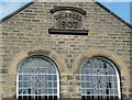
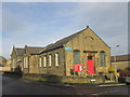
Datestone on Crosland Hill Methodist Chapel, 1907
This date is for the enlargement of the chapel.
Image: © Humphrey Bolton
Taken: 16 Jun 2014
0.19 miles
5
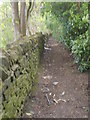
Footpath - Coronation Park - viewed from Pymroyd Lane
Image: © Betty Longbottom
Taken: 10 May 2016
0.21 miles
6
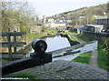
Huddersfield Canal at Milnsbridge
Looking east along the Huddersfield Narrow Canal from Lock 11e at Milnsbridge.
Image: © Martin Clark
Taken: Unknown
0.23 miles
8
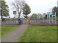
Play Area - Coronation Park - viewed from Pymroyd Lane
Image: © Betty Longbottom
Taken: 10 May 2016
0.24 miles