IMAGES TAKEN NEAR TO
Thackeray Grove, HUDDERSFIELD, HD4 5HD
Introduction
This page details the photographs taken nearby to Thackeray Grove, HD4 5HD by members of the Geograph project.
The Geograph project started in 2005 with the aim of publishing, organising and preserving representative images for every square kilometre of Great Britain, Ireland and the Isle of Man.

There are currently over 7.5m images from over14,400 individuals and you can help contribute to the project by visiting https://www.geograph.org.uk
Image Map
Images are licensed for reuse under creativecommons.org/licenses/by-sa/2.0
Notes
- Clicking on the map will re-center to the selected point.
- The higher the marker number, the further away the image location is from the centre of the postcode.
Image Listing (88 Images Found)
Images are licensed for reuse under creativecommons.org/licenses/by-sa/2.0
Image
Details
Distance
4
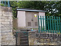
Electricity Substation No 213 - Moor End Road
Image: © Betty Longbottom
Taken: 1 Jun 2016
0.07 miles
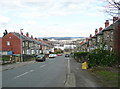
7
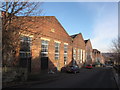
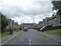
Nabcroft Street, Yews Hill
This is a view of Nabcroft Street looking down towards Lockwood. The sprawling David Brown engineering site, which displays a datestone of 1940, dominates the left of the image.
Image: © Bobby Clegg
Taken: 21 Jan 2011
0.08 miles
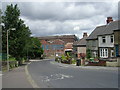
8
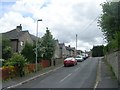
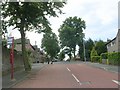
Moor End Road - viewed from Walpole Road
Image: © Betty Longbottom
Taken: 5 Jul 2010
0.08 miles
9
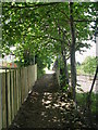
Thornfield Avenue from Moor End Road
Image: © Humphrey Bolton
Taken: 25 Mar 2015
0.08 miles
10
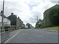
Moor End Road - viewed from Walpole Road
Image: © Betty Longbottom
Taken: 5 Jul 2010
0.09 miles