IMAGES TAKEN NEAR TO
Manchester Road, HUDDERSFIELD, HD4 5BW
Introduction
This page details the photographs taken nearby to Manchester Road, HD4 5BW by members of the Geograph project.
The Geograph project started in 2005 with the aim of publishing, organising and preserving representative images for every square kilometre of Great Britain, Ireland and the Isle of Man.

There are currently over 7.5m images from over14,400 individuals and you can help contribute to the project by visiting https://www.geograph.org.uk
Image Map
Images are licensed for reuse under creativecommons.org/licenses/by-sa/2.0
Notes
- Clicking on the map will re-center to the selected point.
- The higher the marker number, the further away the image location is from the centre of the postcode.
Image Listing (123 Images Found)
Images are licensed for reuse under creativecommons.org/licenses/by-sa/2.0
Image
Details
Distance
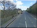
1
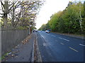
Bus stop on Manchester Road (A62), Huddersfield
Looking east.
Image: © JThomas
Taken: 2 Nov 2018
0.01 miles
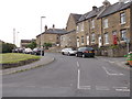
4
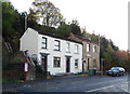
Houses on Manchester Road, Huddersfield
Steps go up the bank to Park Road West.
Image: © JThomas
Taken: 2 Nov 2018
0.04 miles
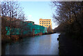
5
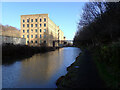
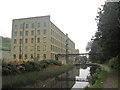
Canal approaching Britannia Mill and Lock 6E, Huddersfield
Image: © Humphrey Bolton
Taken: 12 Aug 2022
0.04 miles
6
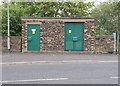
Electricity Substation No 1071 - Park Road West
Image: © Betty Longbottom
Taken: 1 Jun 2016
0.05 miles
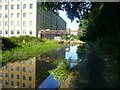
7
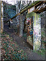
Graffiti on pipe supports near Lock 6E, Huddersfield Narrow Canal, Paddock
Image: © habiloid
Taken: 21 Feb 2022
0.05 miles