IMAGES TAKEN NEAR TO
Britannia Road, HUDDERSFIELD, HD3 4QB
Introduction
This page details the photographs taken nearby to Britannia Road, HD3 4QB by members of the Geograph project.
The Geograph project started in 2005 with the aim of publishing, organising and preserving representative images for every square kilometre of Great Britain, Ireland and the Isle of Man.

There are currently over 7.5m images from over14,400 individuals and you can help contribute to the project by visiting https://www.geograph.org.uk
Image Map
Images are licensed for reuse under creativecommons.org/licenses/by-sa/2.0
Notes
- Clicking on the map will re-center to the selected point.
- The higher the marker number, the further away the image location is from the centre of the postcode.
Image Listing (95 Images Found)
Images are licensed for reuse under creativecommons.org/licenses/by-sa/2.0
Image
Details
Distance
2
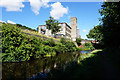
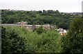
Mills on Britannia Road and the Golcar Aqueduct
The foreground bridge is the Golcar Aqueduct carrying the Huddersfield Narrow Canal over the Colne (this being the Colne Valley). The background mills are clearly the same as in Humphrey Bolton's Image photograph but with less trees.
Image: © Chris Allen
Taken: 29 Apr 1990
0.05 miles
3
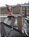
Ventilator, Britannia Road, Golcar
Several of these ventilators have a 'cockscomb' on the top, which might be part of a mechanism for moving a disc to partially close the vent opening. However it seems now to be purely decorative.
Image: © Humphrey Bolton
Taken: 6 Dec 2007
0.06 miles
4
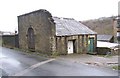
Transformer building, Britannia Road, Golcar
This appears to serve Stanley Mills. Possibly the wall continued to the right, with an arched entrance to the mills.
Image: © Humphrey Bolton
Taken: 6 Dec 2007
0.06 miles
5
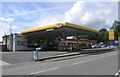
Jet Filling Station - Scar Lane, Milnsbridge
Image: © Betty Longbottom
Taken: 13 Aug 2008
0.07 miles
6
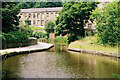
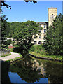
Aqueduct over the River Colne, Huddersfield Narrow Canal
Looking west.
Image: © Dr Neil Clifton
Taken: 7 Jul 2003
0.07 miles
7
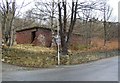
Mysterious brick building, Britannia Road, Golcar
What was this for? I have been informed that it was a bomb shelter. I can guess some of its present uses!
Image: © Humphrey Bolton
Taken: 6 Dec 2007
0.08 miles
8
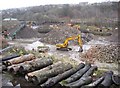
Recycling, Britannia Road, Golcar
My interpretation of this scene is that demolition and excavated material is dumped in the central pile and sorted into good pieces of stone on the right and crushed to make aggregate on the left. In the foreground is a line of tree-trunks, and out-of sight to the left a pile of logs, presumably for firewood. This area was previously covered in mill buildings, probably weaving sheds.
Image: © Humphrey Bolton
Taken: 6 Dec 2007
0.08 miles
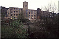
9
Mills on Britannia Road, Golcar
Seen here from across Manchester Road, in Linthwaite across the valley. There has been a considerable growth of trees on the steep sides of the valley since the mid-20C, hiding much of the valley-bottom industry. This part of Golcar was in Huddersfield County Borough.
Image: © Humphrey Bolton
Taken: 12 Jul 2007
0.08 miles
10
Milnsbridge - aqueduct and mill below Scar Wood
For an alternative view, please see Image
Image: © Dave Bevis
Taken: 22 Aug 2011
0.08 miles