IMAGES TAKEN NEAR TO
Celandine Drive, HUDDERSFIELD, HD3 3UT
Introduction
This page details the photographs taken nearby to Celandine Drive, HD3 3UT by members of the Geograph project.
The Geograph project started in 2005 with the aim of publishing, organising and preserving representative images for every square kilometre of Great Britain, Ireland and the Isle of Man.

There are currently over 7.5m images from over14,400 individuals and you can help contribute to the project by visiting https://www.geograph.org.uk
Image Map
Images are licensed for reuse under creativecommons.org/licenses/by-sa/2.0
Notes
- Clicking on the map will re-center to the selected point.
- The higher the marker number, the further away the image location is from the centre of the postcode.
Image Listing (77 Images Found)
Images are licensed for reuse under creativecommons.org/licenses/by-sa/2.0
Image
Details
Distance
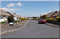
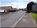
2
Celandine Avenue - looking towards Raw Nook Road
Image: © Betty Longbottom
Taken: 5 Jun 2015
0.06 miles
3
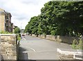
Laund Road, Salendine Nook, Lindley cum Quarmby
This is the bottom end of the road, at the closed junction with New Hey Road. The large graveyard of Salendine Nook Baptist Chapel is on the right, and the modern flats were built on the site of the Sunday School.
Image: © Humphrey Bolton
Taken: 28 Jun 2007
0.06 miles
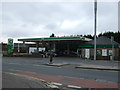
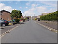
7
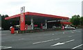
Total Filling Station - New Hey Road, Salendine Nook
Image: © Betty Longbottom
Taken: 24 May 2008
0.08 miles
8
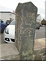
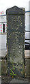
Old guidestone
In the wall surrounding Sainsbury's supermarket on the A640, New Hey Road, at Salendine Nook is this distinctive old guidestone pointing the way to Lindley and Lockwood. It has weathered during the last few years and the inscription is not as clear as it was. There is a bench mark near the top of the left-hand side. It may date from the late 18th century.
Image: © Chris Minto
Taken: 7 Mar 2021
0.08 miles
9
Waymarker, New Hey Road (A640), Salendine Nook, Huddersfield
The way marker reads:
"To Lindley
To Longwood".
It can be seen in context in Image A close-up of a benchmark on the side of it can be seen in Image
Image: © habiloid
Taken: 11 Jul 2024
0.08 miles
10
Benchmark on waymarker, New Hey Road (A640), Salendine Nook, Huddersfield
Image: © habiloid
Taken: 11 Jul 2024
0.08 miles