IMAGES TAKEN NEAR TO
Crosland Road, HUDDERSFIELD, HD3 3PW
Introduction
This page details the photographs taken nearby to Crosland Road, HD3 3PW by members of the Geograph project.
The Geograph project started in 2005 with the aim of publishing, organising and preserving representative images for every square kilometre of Great Britain, Ireland and the Isle of Man.

There are currently over 7.5m images from over14,400 individuals and you can help contribute to the project by visiting https://www.geograph.org.uk
Image Map
Images are licensed for reuse under creativecommons.org/licenses/by-sa/2.0
Notes
- Clicking on the map will re-center to the selected point.
- The higher the marker number, the further away the image location is from the centre of the postcode.
Image Listing (64 Images Found)
Images are licensed for reuse under creativecommons.org/licenses/by-sa/2.0
Image
Details
Distance
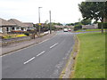
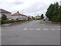
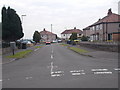
4
Crosland Road - viewed from Burniston Drive
Image: © Betty Longbottom
Taken: 23 Jun 2015
0.06 miles
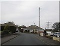
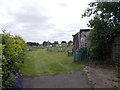
6
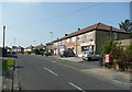
Neighbourhood shops, Burniston Road, Lindley
These seems to have been built as an integral part of the housing development of this area.
Image: © Humphrey Bolton
Taken: 18 Sep 2008
0.07 miles