IMAGES TAKEN NEAR TO
Lea Street, HUDDERSFIELD, HD3 3LS
Introduction
This page details the photographs taken nearby to Lea Street, HD3 3LS by members of the Geograph project.
The Geograph project started in 2005 with the aim of publishing, organising and preserving representative images for every square kilometre of Great Britain, Ireland and the Isle of Man.

There are currently over 7.5m images from over14,400 individuals and you can help contribute to the project by visiting https://www.geograph.org.uk
Image Map
Images are licensed for reuse under creativecommons.org/licenses/by-sa/2.0
Notes
- Clicking on the map will re-center to the selected point.
- The higher the marker number, the further away the image location is from the centre of the postcode.
Image Listing (79 Images Found)
Images are licensed for reuse under creativecommons.org/licenses/by-sa/2.0
Image
Details
Distance
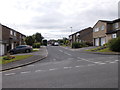
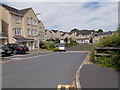
2
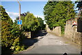
Barrier on Daisy Lea Lane
Part of the lane is in a private estate, and the barrier here ensures that it is not used as a cut through.
Image: © Bill Boaden
Taken: 1 Jul 2013
0.07 miles
6
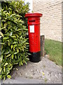
Edward VII Postbox - Holly Bank Road
Image: © Betty Longbottom
Taken: 20 Jul 2015
0.08 miles
8
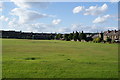
Lindley Playing Fields
A useful open space which no doubt some have considered for development.
Image: © Bill Boaden
Taken: 1 Jul 2013
0.09 miles
10
Electricity Substation No 1285 - Daisy Lea Lane
Image: © Betty Longbottom
Taken: 20 Jul 2015
0.11 miles