IMAGES TAKEN NEAR TO
Stirling Wood Close, HUDDERSFIELD, HD3 3HT
Introduction
This page details the photographs taken nearby to Stirling Wood Close, HD3 3HT by members of the Geograph project.
The Geograph project started in 2005 with the aim of publishing, organising and preserving representative images for every square kilometre of Great Britain, Ireland and the Isle of Man.

There are currently over 7.5m images from over14,400 individuals and you can help contribute to the project by visiting https://www.geograph.org.uk
Image Map
Images are licensed for reuse under creativecommons.org/licenses/by-sa/2.0
Notes
- Clicking on the map will re-center to the selected point.
- The higher the marker number, the further away the image location is from the centre of the postcode.
Image Listing (89 Images Found)
Images are licensed for reuse under creativecommons.org/licenses/by-sa/2.0
Image
Details
Distance
1
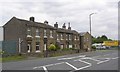
Terrace houses, Lindley Moor Road, Fixby
Another row of houses with faded names on the door lintels. They join onto the row in Acton Flat Lane, at an awkward angle.
Image: © Humphrey Bolton
Taken: 28 Jun 2007
0.02 miles
2
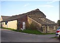
Barn at Warren House Farm, Fixby
Unfortunately the gable end is disintegrating. Keeping traditional farm buildings in good repair can be expensive.
Image: © Humphrey Bolton
Taken: 9 Sep 2006
0.02 miles
3
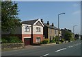
Houses, Lindley Moor Rd, Fixby
A modern detached house continues the ribbon development of stone terrace houses.
Image: © Humphrey Bolton
Taken: 18 Sep 2008
0.04 miles
4
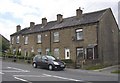
Terrace houses, Lindley Moor Road, Fixby
I shouldn't think that these were miners' cottages. They each have a name painted on the door lintel, e.g. Well Cottage, and were perhaps aimed at the lower middle class of the late 19C, but they are a long way from the nearest town.
Image: © Humphrey Bolton
Taken: 28 Jun 2007
0.04 miles
5
Factory offices, Lindley Moor Road, Fixby
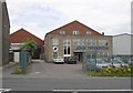
John Fredericks makes plastic doors, windows and conservatories. The offices are, as often, built onto the front of the factory building. As far as I know these are the only industrial premises in Fixby.
Image: © Humphrey Bolton
Taken: 28 Jun 2007
0.04 miles
8
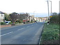
Lindley Moor Road - Weather Hill Road
Image: © Betty Longbottom
Taken: 27 Oct 2014
0.05 miles
9
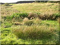
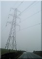
Wet area off Lindley Road, Lindley
The footpath from Lindley Road to Warren House passes a wet area where a stream has no visible channel.
Image: © Humphrey Bolton
Taken: 9 Sep 2006
0.06 miles
10
Footpath off Lindley Road, Lindley
This path leads to Warren House Farm, in the background.
Image: © Humphrey Bolton
Taken: 9 Sep 2006
0.06 miles