IMAGES TAKEN NEAR TO
Gibson Street, HUDDERSFIELD, HD3 3HB
Introduction
This page details the photographs taken nearby to Gibson Street, HD3 3HB by members of the Geograph project.
The Geograph project started in 2005 with the aim of publishing, organising and preserving representative images for every square kilometre of Great Britain, Ireland and the Isle of Man.

There are currently over 7.5m images from over14,400 individuals and you can help contribute to the project by visiting https://www.geograph.org.uk
Image Map
Images are licensed for reuse under creativecommons.org/licenses/by-sa/2.0
Notes
- Clicking on the map will re-center to the selected point.
- The higher the marker number, the further away the image location is from the centre of the postcode.
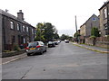
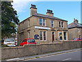
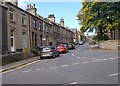
Image Listing (104 Images Found)
Images are licensed for reuse under creativecommons.org/licenses/by-sa/2.0
Image
Details
Distance
2
Catholic Church of St James the Great - New Hey Road
Image: © Betty Longbottom
Taken: 24 May 2008
0.02 miles
3
Lindley Evangelical Church - Acre Street
Image: © Betty Longbottom
Taken: 16 Sep 2015
0.04 miles
5
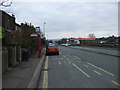
Bus stop and shelter on New Hey Road (A640)
Image: © JThomas
Taken: 14 Mar 2015
0.05 miles

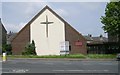
8
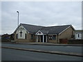
Salvation Army Church and Community Centre
On New Hey Road (A640).
Image: © JThomas
Taken: 14 Mar 2015
0.07 miles
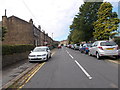
10
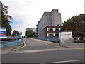
Huddersfield Royal Infirmary - viewed from Acre Street
Image: © Betty Longbottom
Taken: 16 Sep 2015
0.07 miles