IMAGES TAKEN NEAR TO
Oaklands Crescent, HUDDERSFIELD, HD2 2FX
Introduction
This page details the photographs taken nearby to Oaklands Crescent, HD2 2FX by members of the Geograph project.
The Geograph project started in 2005 with the aim of publishing, organising and preserving representative images for every square kilometre of Great Britain, Ireland and the Isle of Man.

There are currently over 7.5m images from over14,400 individuals and you can help contribute to the project by visiting https://www.geograph.org.uk
Image Map
Images are licensed for reuse under creativecommons.org/licenses/by-sa/2.0
Notes
- Clicking on the map will re-center to the selected point.
- The higher the marker number, the further away the image location is from the centre of the postcode.
Image Listing (69 Images Found)
Images are licensed for reuse under creativecommons.org/licenses/by-sa/2.0
Image
Details
Distance
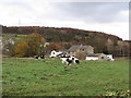
2
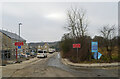
Yew Tree Road, Birchencliffe, Huddersfield
Image: © habiloid
Taken: 13 Feb 2023
0.08 miles
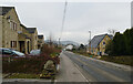
3
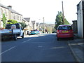
A view from Yew Tree Road, Birchencliffe, Huddersfield
Image: © habiloid
Taken: 13 Feb 2023
0.08 miles
4
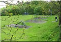
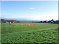
Birchencliffe Recreation Ground, Birchencliffe, Huddersfield
Image: © habiloid
Taken: 13 Feb 2023
0.10 miles
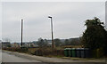
5
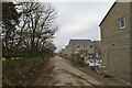
The Kirklees Way heading away from Burn Road, Birchencliffe, Huddersfield
Image: © habiloid
Taken: 13 Feb 2023
0.11 miles
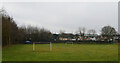
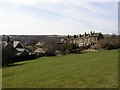
9
Birchencliffe Cricket Ground - Halifax Road
Image: © Betty Longbottom
Taken: 27 Oct 2014
0.12 miles
10
Stone, Fixby
At SE120193. This is the name of this group of houses on Burn Road, seen from Grimescar Road.
Image: © Humphrey Bolton
Taken: 22 Mar 2006
0.12 miles