IMAGES TAKEN NEAR TO
Dagmar Avenue, WEMBLEY, HA9 8UP
Introduction
This page details the photographs taken nearby to Dagmar Avenue, HA9 8UP by members of the Geograph project.
The Geograph project started in 2005 with the aim of publishing, organising and preserving representative images for every square kilometre of Great Britain, Ireland and the Isle of Man.

There are currently over 7.5m images from over14,400 individuals and you can help contribute to the project by visiting https://www.geograph.org.uk
Image Map
Images are licensed for reuse under creativecommons.org/licenses/by-sa/2.0
Notes
- Clicking on the map will re-center to the selected point.
- The higher the marker number, the further away the image location is from the centre of the postcode.
Image Listing (73 Images Found)
Images are licensed for reuse under creativecommons.org/licenses/by-sa/2.0
Image
Details
Distance
1
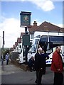
The Green Man, Wembley Hill
Football supporters' buses parking at the Dagmar Avenue entrance to the pub, where refreshments were to be taken before the match.
Image: © Stanley Howe
Taken: 13 May 2012
0.04 miles
2
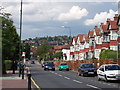
Park Lane Wembley, Barn Hill behind
This view of houses in Park Lane is taken from Wembley Hill looking North towards Barn Hill
Image: © David Hawgood
Taken: 30 Jul 2005
0.06 miles
3
The Green Man
A suburban pub in Dagmar Avenue which probably does most of its trade when there's football on down the road at Wembley Stadium.
Image: © Des Blenkinsopp
Taken: 30 Mar 2016
0.06 miles
4
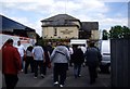
The Green Man, Wembley Hill
Football fans from County Durham arriving by bus, and disembarking for sustenance prior to kick-off in the FA Vase Final.
Image: © Stanley Howe
Taken: 13 May 2012
0.06 miles
5
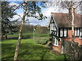
House in the Park
I'm guessing this would have been the Park Keeper's house back when such jobs existed.
Image: © Des Blenkinsopp
Taken: 30 Mar 2016
0.08 miles
6
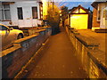
Path from Kingsway to Park Lane, Wembley
Image: © David Howard
Taken: 5 Feb 2015
0.12 miles
7
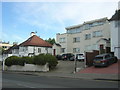
Houses and flats on Wembley Hill Road
Image: © Christopher Hilton
Taken: 2 Sep 2016
0.12 miles
8

Pots in the Park
The King Edward 7 Park in Park Lane.
Image: © Des Blenkinsopp
Taken: 30 Mar 2016
0.13 miles
9
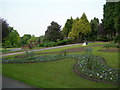
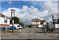
King Edward VII Park, Wembley
Park Lane Wembley is to the right. Here is a Brent Council link about the park http://www.brent.gov.uk/parks.nsf/parks/King+Edward+VII+Park?OpenDocument
Image: © Danny P Robinson
Taken: 3 Jun 2007
0.13 miles
10
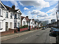
Dagmar Avenue, Wembley
You tend not to notice topography so much when it's covered with houses, but this is looking downhill to the Brent Valley.
Image: © Des Blenkinsopp
Taken: 30 Mar 2016
0.13 miles