1
Brent River Park
This is actually a wildflower meadow, created in recompense for a small loss of parkland when the North Circular Road was widened in the 1990s. The land was re-contoured and the area was seeded with a wildflower mix.
Image: © Marathon
Taken: 22 Oct 2014
0.09 miles
2
Rusty Structure, Tokyngton Park
I guess this is some sort of Performance area, Stage, Bandstand or whatever.
A small band could play here for sure. Heavy Metal probably.
Image: © Des Blenkinsopp
Taken: 7 Apr 2014
0.09 miles
3
Sculpture in Brent River Park
This is actually a wildflower meadow, created in recompense for a small loss of parkland when the North Circular Road was widened in the 1990s. The land was re-contoured and the area was seeded with a wildflower mix.
Image: © Marathon
Taken: 22 Oct 2014
0.10 miles
4
Playground in Brent River Park
Image: © David Smith
Taken: 23 Nov 2017
0.11 miles
5
The Climate Pavilion in Brent River Park
This delicate structure symbolises the delicate balance of the world's climate and the dangers of climate change. It is supposed to be an educational installation
Image]
Image: © David Smith
Taken: 23 Nov 2017
0.11 miles
6
Plaque for the Climate Pavilion in Brent River Park
This describes the purpose of the structure
Image] by the river in the park
Image: © David Smith
Taken: 23 Nov 2017
0.11 miles
7
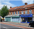
Harrow Road shops north of Monks Park, Tokyngton
Tokyngton, part of the London Borough of Brent and Wembley postal area,
is located south of the suburb of Wembley.
Image: © Jaggery
Taken: 13 May 2012
0.13 miles
8
A pharmacy and a cultural centre, Tokyngton
Monks Chem Ltd pharmacy is at 70 Harrow Road. Next door, the Islamic Cultural Centre (Wembley) is
at the NW end of a long row of shops. Beyond are houses.
Image: © Jaggery
Taken: 13 May 2012
0.13 miles
9
Harrow Road, A404, with a row of shops
Image: © David Smith
Taken: 23 Nov 2017
0.14 miles
10
River Brent in Brent River Park
The River Brent starts where the Dollis Brook and Mutton Brook meet in Hendon and eventually flows into the Thames at Brentford, sharing much of the last part of its course with the Grand Union Canal. Much of its course has been straightened and put into a concrete straightjacket as here. The purpose was to reduce the risk of local flooding by allowing the water to flow rapidly and unhindered out of the area. John Betjeman touched on this in his poem 'Middlesex':
"Gentle Brent, I used to know you
Wandering Wembley-wards at will,
Now what change your waters show you
In the meadowlands you fill,"
Further upriver in Brent River Park a more natural course for the river has been created.
Image: © Marathon
Taken: 22 Oct 2014
0.15 miles


