IMAGES TAKEN NEAR TO
Monks Park, WEMBLEY, HA9 6JE
Introduction
This page details the photographs taken nearby to Monks Park, HA9 6JE by members of the Geograph project.
The Geograph project started in 2005 with the aim of publishing, organising and preserving representative images for every square kilometre of Great Britain, Ireland and the Isle of Man.

There are currently over 7.5m images from over14,400 individuals and you can help contribute to the project by visiting https://www.geograph.org.uk
Image Map
Images are licensed for reuse under creativecommons.org/licenses/by-sa/2.0
Notes
- Clicking on the map will re-center to the selected point.
- The higher the marker number, the further away the image location is from the centre of the postcode.
Image Listing (44 Images Found)
Images are licensed for reuse under creativecommons.org/licenses/by-sa/2.0
Image
Details
Distance
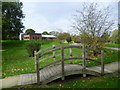
1
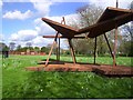
Rusty Structure, Tokyngton Park
I guess this is some sort of Performance area, Stage, Bandstand or whatever.
A small band could play here for sure. Heavy Metal probably.
Image: © Des Blenkinsopp
Taken: 7 Apr 2014
0.06 miles
3
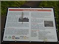
Plaque for the Climate Pavilion in Brent River Park
This describes the purpose of the structure Image] by the river in the park
Image: © David Smith
Taken: 23 Nov 2017
0.09 miles
4
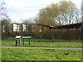
The Climate Pavilion in Brent River Park
This delicate structure symbolises the delicate balance of the world's climate and the dangers of climate change. It is supposed to be an educational installation Image]
Image: © David Smith
Taken: 23 Nov 2017
0.09 miles
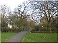
5
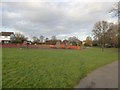
Brent River Park
This is actually a wildflower meadow, created in recompense for a small loss of parkland when the North Circular Road was widened in the 1990s. The land was re-contoured and the area was seeded with a wildflower mix.
Image: © Marathon
Taken: 22 Oct 2014
0.10 miles
6
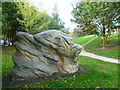
Sculpture in Brent River Park
This is actually a wildflower meadow, created in recompense for a small loss of parkland when the North Circular Road was widened in the 1990s. The land was re-contoured and the area was seeded with a wildflower mix.
Image: © Marathon
Taken: 22 Oct 2014
0.11 miles
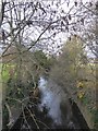
9
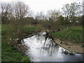
River Brent
River Brent in Tokyngton Recreation Ground
Image: © Shaun Ferguson
Taken: 27 Mar 2009
0.15 miles
10
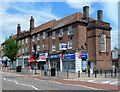
Harrow Road shops north of Monks Park, Tokyngton
Tokyngton, part of the London Borough of Brent and Wembley postal area,
is located south of the suburb of Wembley.
Image: © Jaggery
Taken: 13 May 2012
0.15 miles