IMAGES TAKEN NEAR TO
Tokyngton Avenue, WEMBLEY, HA9 6HE
Introduction
This page details the photographs taken nearby to Tokyngton Avenue, HA9 6HE by members of the Geograph project.
The Geograph project started in 2005 with the aim of publishing, organising and preserving representative images for every square kilometre of Great Britain, Ireland and the Isle of Man.

There are currently over 7.5m images from over14,400 individuals and you can help contribute to the project by visiting https://www.geograph.org.uk
Image Map
Images are licensed for reuse under creativecommons.org/licenses/by-sa/2.0
Notes
- Clicking on the map will re-center to the selected point.
- The higher the marker number, the further away the image location is from the centre of the postcode.
Image Listing (40 Images Found)
Images are licensed for reuse under creativecommons.org/licenses/by-sa/2.0
Image
Details
Distance
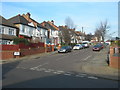
1
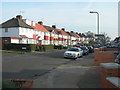
Tokyngton Avenue, Wembley
At the junction of Tring Avenue.
Image: © Danny P Robinson
Taken: 4 Feb 2007
0.01 miles
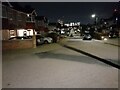
3
Tokyngton Avenue, Wembley
At the end of Nettleden Avenue
Image: © David Howard
Taken: 12 Oct 2022
0.03 miles
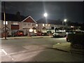
4
Flamsted Avenue, Wembley
At the junction of Tokyngton Avenue.
Image: © Danny P Robinson
Taken: 4 Feb 2007
0.07 miles
6
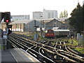
Bakerloo train waits to leave Stonebridge Park depot
Image: © Peter Whatley
Taken: 10 Apr 2011
0.11 miles

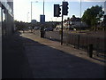
8
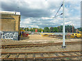
London Borough of Brent : Stonebridge Park Depot
On the Bakerloo Line looking across Stonebridge Park Depot.
Image: © Lewis Clarke
Taken: 18 Jul 2019
0.13 miles
9

St Michael, St Michael's Avenue, Tokyngton, Middlesex - Font
Image: © John Salmon
Taken: 1 Aug 2004
0.14 miles
10

St Michael, St Michael's Avenue, Tokyngton, Middlesex - Organ
Image: © John Salmon
Taken: 1 Aug 2004
0.15 miles