IMAGES TAKEN NEAR TO
Atlas Road, WEMBLEY, HA9 0TZ
Introduction
This page details the photographs taken nearby to Atlas Road, HA9 0TZ by members of the Geograph project.
The Geograph project started in 2005 with the aim of publishing, organising and preserving representative images for every square kilometre of Great Britain, Ireland and the Isle of Man.

There are currently over 7.5m images from over14,400 individuals and you can help contribute to the project by visiting https://www.geograph.org.uk
Image Map
Images are licensed for reuse under creativecommons.org/licenses/by-sa/2.0
Notes
- Clicking on the map will re-center to the selected point.
- The higher the marker number, the further away the image location is from the centre of the postcode.
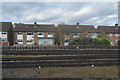
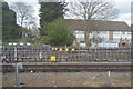
Image Listing (33 Images Found)
Images are licensed for reuse under creativecommons.org/licenses/by-sa/2.0
Image
Details
Distance
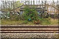
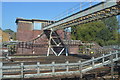
1
Van yard by the railway line
Near to the new Wembley Stadium.
Image: © Stephen Sweeney
Taken: 25 Jun 2007
0.06 miles
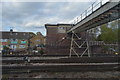
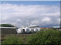
6
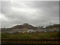
Digger on a pile of rubbish?
Alongside the railway line.
Image: © Steve Fareham
Taken: 10 Sep 2010
0.08 miles