IMAGES TAKEN NEAR TO
Orchard Crescent, EDGWARE, HA8 9PP
Introduction
This page details the photographs taken nearby to Orchard Crescent, HA8 9PP by members of the Geograph project.
The Geograph project started in 2005 with the aim of publishing, organising and preserving representative images for every square kilometre of Great Britain, Ireland and the Isle of Man.

There are currently over 7.5m images from over14,400 individuals and you can help contribute to the project by visiting https://www.geograph.org.uk
Image Map
Images are licensed for reuse under creativecommons.org/licenses/by-sa/2.0
Notes
- Clicking on the map will re-center to the selected point.
- The higher the marker number, the further away the image location is from the centre of the postcode.
Image Listing (69 Images Found)
Images are licensed for reuse under creativecommons.org/licenses/by-sa/2.0
Image
Details
Distance
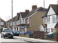
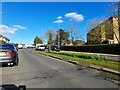
4
Hale Lane, Edgware
At the corner of Alders Road
Image: © David Howard
Taken: 10 Mar 2022
0.10 miles
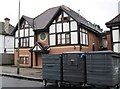
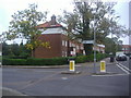
5
Deans Lane, Burnt Oak
John Keble Church is on the right.
Image: © David Howard
Taken: 17 Mar 2022
0.10 miles
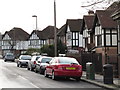
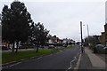
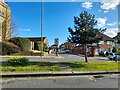
6
Along Hale Lane
Looking towards Stoneyfields Lane opposite.
Image: © DS Pugh
Taken: 31 Dec 2018
0.11 miles
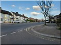
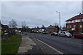
7
Hale Lane, HA8
Between Highview Avenue and Farm Road.
Image: © Mike Quinn
Taken: 14 Feb 2012
0.11 miles
8
Along Dean's Lane
Looking along a wide street in Edgware.
Image: © DS Pugh
Taken: 31 Dec 2018
0.11 miles
9
Deans Lane, Burnt Oak
Looking towards Church Close with John Keble Church on the left.
Image: © David Howard
Taken: 17 Mar 2022
0.11 miles
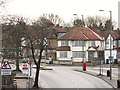
10
Stoneyfields Lane at the junction of Hale Lane
Image: © David Howard
Taken: 2 Oct 2013
0.11 miles