IMAGES TAKEN NEAR TO
Fairfield Crescent, EDGWARE, HA8 9AF
Introduction
This page details the photographs taken nearby to Fairfield Crescent, HA8 9AF by members of the Geograph project.
The Geograph project started in 2005 with the aim of publishing, organising and preserving representative images for every square kilometre of Great Britain, Ireland and the Isle of Man.

There are currently over 7.5m images from over14,400 individuals and you can help contribute to the project by visiting https://www.geograph.org.uk
Image Map
Images are licensed for reuse under creativecommons.org/licenses/by-sa/2.0
Notes
- Clicking on the map will re-center to the selected point.
- The higher the marker number, the further away the image location is from the centre of the postcode.
Image Listing (51 Images Found)
Images are licensed for reuse under creativecommons.org/licenses/by-sa/2.0
Image
Details
Distance
1
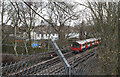
Northern Line from Deansbrook Road
An Edgware bound train slows to a crawl as it waits for a departing service to free up a platform. The train is made up of 1995 stock with Driving Motor 51587 bring up the rear. In the foreground are some of the modern defences against trespassers. Beyond are houses on Fairfield Crescent.
Image: © Martin Addison
Taken: 25 Feb 2011
0.04 miles
2
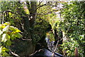
Edgware Brook flowing beside Heming Road
Image: © Christopher Hilton
Taken: 19 Apr 2017
0.12 miles
3
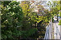
Edgware Brook from Heming Road
Looking upstream, the brook emerging from between gardens.
Image: © Christopher Hilton
Taken: 19 Apr 2017
0.13 miles
4
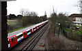
Northern Line From Deansbrook Road
A train of 1995 stock makes its way south from Edgware towards Burnt Oak station. On the right is Edgware Community Hospital. The footpath beside the railway connects Deansbrook Road with Watling Avenue.
Image: © Martin Addison
Taken: 25 Feb 2011
0.13 miles
5
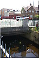
Edgware Brook passes under Deansbrook Road
Image: © Christopher Hilton
Taken: 19 Apr 2017
0.13 miles
6
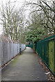
Footpath to Watling Avenue
Seen close to the Deansbrook Road end. The railings on the right are the boundary fence for Edgware Community Hospital. The fence on the right is the boundary of the Northern Line, which the footpath follows down to adjacent to Burnt Oak station.
Image: © Martin Addison
Taken: 25 Feb 2011
0.14 miles
9
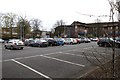
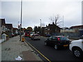
Edgware Community Hospital
Looking across the staff car park from the footpath beside the Northern Line.
Image: © Martin Addison
Taken: 25 Feb 2011
0.17 miles
10
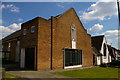
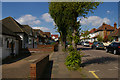
Methodist Church, Elmer Gardens, Edgware
Image: © Christopher Hilton
Taken: 19 Apr 2017
0.18 miles