IMAGES TAKEN NEAR TO
Church Way, EDGWARE, HA8 9AA
Introduction
This page details the photographs taken nearby to Church Way, HA8 9AA by members of the Geograph project.
The Geograph project started in 2005 with the aim of publishing, organising and preserving representative images for every square kilometre of Great Britain, Ireland and the Isle of Man.

There are currently over 7.5m images from over14,400 individuals and you can help contribute to the project by visiting https://www.geograph.org.uk
Image Map
Images are licensed for reuse under creativecommons.org/licenses/by-sa/2.0
Notes
- Clicking on the map will re-center to the selected point.
- The higher the marker number, the further away the image location is from the centre of the postcode.
Image Listing (208 Images Found)
Images are licensed for reuse under creativecommons.org/licenses/by-sa/2.0
Image
Details
Distance
2
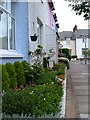
Garden City, Edgware
A Picturesque view showing a nicely kept little garden and some of the houses (which are all painted in different colours).
Image: © Jonathan FeBland
Taken: 2 May 2006
0.07 miles
3
Manor Park Gardens
An October view of Manor Park Gardens as seen from Manor Park Crescent, Edgware, Middlesex.
Image: © Jonathan FeBland
Taken: 26 Oct 2006
0.07 miles
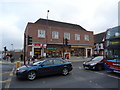
4
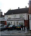
Edgware Constitutional Club
The white metal pointy thing is for hanging flags on before England get knocked out of World Cups etc.
Image: © Jonathan FeBland
Taken: 26 Oct 2006
0.07 miles
5
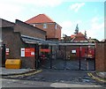
Edgware Sorting Office
This is where you go to pick up those packages that were too large to fit through your front door and you were either a) out or b) too drowsy to answer at the time.
Image: © Jonathan FeBland
Taken: 26 Oct 2006
0.07 miles
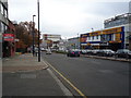
6
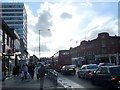
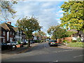
Station Road, Edgware
A normal October's day in central Edgware, Middlesex.
Image: © Jonathan FeBland
Taken: 26 Oct 2006
0.07 miles
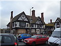
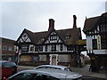
7
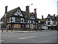
Edgware: The Railway public house
This has to be one of the finest examples in the land of that 1930s phenomenon, the Mock Tudor pub. This one even has a separate lodge, on the right, connected to the main building by a covered archway that goes over the entrance to the stables, (aka the car park). There are classic chimneys and, beneath the first floor windows, heraldic crests.
Alas the building is boarded up and closed. In fact this is just another footnote in the saga of the demise of the former Great Northern Railway (GNR)'s branch line to Edgware. The line opened in 1867 and was the first railway to be built to Edgware from London. The terminus station occupied the site immediately to the left of this building, now the Broadwalk Shopping Centre. The first Railway hotel followed shortly afterwards in 1870, but that was demolished in 1930 to be replaced by the current Mock Tudor pub on the site in 1932. But the underground station at Edgware was opened in 1924, with its terminus immediately to the north-east of the GNR one, and, faced with the competition on a more direct route to London, the former GNR line, by this time run by the London & North Eastern Railway, closed to passengers in 1939, and the station was subsequently demolished.
So The Railway is a reminder of Edgware's original station, not the current one.
Image: © Nigel Cox
Taken: 25 Jul 2009
0.08 miles