IMAGES TAKEN NEAR TO
Harcourt Avenue, EDGWARE, HA8 8YJ
Introduction
This page details the photographs taken nearby to Harcourt Avenue, HA8 8YJ by members of the Geograph project.
The Geograph project started in 2005 with the aim of publishing, organising and preserving representative images for every square kilometre of Great Britain, Ireland and the Isle of Man.

There are currently over 7.5m images from over14,400 individuals and you can help contribute to the project by visiting https://www.geograph.org.uk
Image Map
Images are licensed for reuse under creativecommons.org/licenses/by-sa/2.0
Notes
- Clicking on the map will re-center to the selected point.
- The higher the marker number, the further away the image location is from the centre of the postcode.
Image Listing (13 Images Found)
Images are licensed for reuse under creativecommons.org/licenses/by-sa/2.0
Image
Details
Distance
3
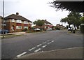
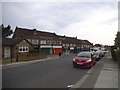
Kenilworth Road at the junction of Glengall Road
Image: © David Howard
Taken: 24 Jun 2015
0.12 miles
4
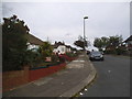
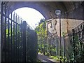
Footpath from The Fairway to Stoneyfields Park
Going under the M1 Motorway and railway lines first.
Image: © David Howard
Taken: 8 Oct 2008
0.14 miles
5
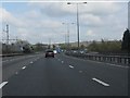
Leaving the railway alignment
Having paralleled the railway route from St Pancras since its start, the M1 curves away preparatory to bridging the line north of London Gateway (Scratchwood) Services. The parapet for the bridge over the services' private access road can just be seen.
Image: © Peter Whatley
Taken: 3 Apr 2012
0.14 miles
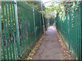
9
Path under the railway leading to Stoneyfields Park
Image: © David Howard
Taken: 8 Oct 2008
0.21 miles
10
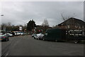
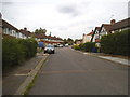
Ellesmere Avenue, Mill Hill
The road at the end is private access to Scratchwood Services, now called London Gateway
Image: © David Howard
Taken: 6 Feb 2021
0.21 miles