IMAGES TAKEN NEAR TO
Meadfield, EDGWARE, HA8 8XN
Introduction
This page details the photographs taken nearby to Meadfield, HA8 8XN by members of the Geograph project.
The Geograph project started in 2005 with the aim of publishing, organising and preserving representative images for every square kilometre of Great Britain, Ireland and the Isle of Man.

There are currently over 7.5m images from over14,400 individuals and you can help contribute to the project by visiting https://www.geograph.org.uk
Image Map
Images are licensed for reuse under creativecommons.org/licenses/by-sa/2.0
Notes
- Clicking on the map will re-center to the selected point.
- The higher the marker number, the further away the image location is from the centre of the postcode.
Image Listing (32 Images Found)
Images are licensed for reuse under creativecommons.org/licenses/by-sa/2.0
Image
Details
Distance
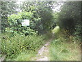
1
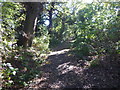
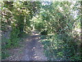
An ancient wooded lane in Edgware
Edgwarebury Lane is a classic example of how the Green Belt works. It leads from Barnet Lane southwards towards the Broadfields Estate at Edgware. It seems like real unspoilt countryside. This view is after Edgwarebury Lane has been left and the path follows an ancient route through woodland belts to Bushfield Crescent where it emerges alongside Broadfields Primary School.
Image: © Marathon
Taken: 26 Sep 2018
0.02 miles
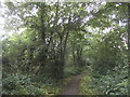
4
An ancient wooded lane in Edgware
Edgwarebury Lane is a classic example of how the Green Belt works. It leads from Barnet Lane southwards towards the Broadfields Estate at Edgware. It seems like real unspoilt countryside. This view is after Edgwarebury Lane has been left and the path follows an ancient route through woodland belts to Bushfield Crescent where it emerges alongside Broadfields Primary School.
Image: © Marathon
Taken: 26 Sep 2018
0.05 miles
5
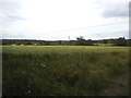
Field by Clay Lane, Edgware
Looking towards the M1 motorway and railway line from St Pancras.
Image: © David Howard
Taken: 24 Jun 2015
0.06 miles
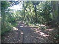
6
An ancient wooded lane in Edgware
Edgwarebury Lane is a classic example of how the Green Belt works. It leads from Barnet Lane southwards towards the Broadfields Estate at Edgware. It seems like real unspoilt countryside. This view is after Edgwarebury Lane has been left and the path follows an ancient route through woodland belts to Bushfield Crescent where it emerges alongside Broadfields Primary School.
Image: © Marathon
Taken: 26 Sep 2018
0.08 miles
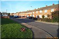
8
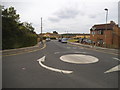
Bushfield Crescent at the junction of Meadfield
Image: © David Howard
Taken: 24 Jun 2015
0.10 miles
9
Edgware: Meadfield
Viewed looking northwards.
Image: © Nigel Cox
Taken: 17 Dec 2005
0.10 miles
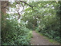
10
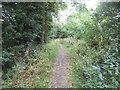
The entrance to Clay Lane, Edgware
This is a public bridleway leading to Edgwarebury Lane
Image: © David Howard
Taken: 24 Jun 2015
0.10 miles