IMAGES TAKEN NEAR TO
Edgware Way, EDGWARE, HA8 8HT
Introduction
This page details the photographs taken nearby to Edgware Way, HA8 8HT by members of the Geograph project.
The Geograph project started in 2005 with the aim of publishing, organising and preserving representative images for every square kilometre of Great Britain, Ireland and the Isle of Man.

There are currently over 7.5m images from over14,400 individuals and you can help contribute to the project by visiting https://www.geograph.org.uk
Image Map
Images are licensed for reuse under creativecommons.org/licenses/by-sa/2.0
Notes
- Clicking on the map will re-center to the selected point.
- The higher the marker number, the further away the image location is from the centre of the postcode.
Image Listing (18 Images Found)
Images are licensed for reuse under creativecommons.org/licenses/by-sa/2.0
Image
Details
Distance
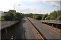
6
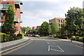
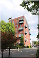
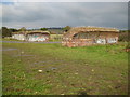
Green Lane, Edgware
The old 1950s grotty council estate has been replaced with very high class housing. There were originally a few tall tower blocks on this site.
Image: © David Howard
Taken: 7 May 2020
0.15 miles
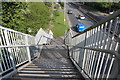
8
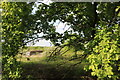
Field by Edgware Way
You can just see the footings of the bridge which was started to extend the Northern Line from Edgware to Elstree but was abandoned due to WW2 and left to decay ever since.
Image: © David Howard
Taken: 7 May 2020
0.19 miles
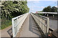
9
Edgwarebury: Derelict railway viaduct
These odd brick remains in the fields east of what is now the A41 Edgware Way are the only surviving civil engineering reminders of the proposed extension of London Underground's Northern Line beyond Edgware to Bushey Heath.
The extension was proposed as part of the 1935 - 1940 New Works programme. A reserved corridor for the railway was left between the housing developments north of Edgware station and this viaduct was constructed to carry the railway over low ground near Edgwarebury Brook and up to Brockley Hill. However the onset of the Second World War brought a halt to construction and after the war the 1947 Town and Country Planning Act gave Green Belt status to all the open land north of Edgware which had previously been earmarked for housing. Without the housing it was thought that the railway would have had little traffic and little purpose and the proposed extension to Bushey Heath was truncated to a station at Brockley Hill in 1950, and the entire plan was abandoned in 1953. The reserved corridor was then sold off for housing and the infill estates of Campbell Croft, Shelley Close, and Sterling Avenue in Edgware were built.
The viaduct itself has gradually crumbled away leaving only the brick piers and short sections of the arches beyond the springer points, as visible in this image.
Image: © Nigel Cox
Taken: 30 Oct 2008
0.20 miles
10
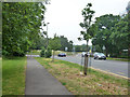
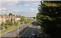
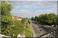
A41 / A410 roundabout
The near road is the A410, linking the A5 and the roughly parallel A41.
Image: © Robin Webster
Taken: 14 Jun 2015
0.21 miles