IMAGES TAKEN NEAR TO
Ranelagh Close, EDGWARE, HA8 8HL
Introduction
This page details the photographs taken nearby to Ranelagh Close, HA8 8HL by members of the Geograph project.
The Geograph project started in 2005 with the aim of publishing, organising and preserving representative images for every square kilometre of Great Britain, Ireland and the Isle of Man.

There are currently over 7.5m images from over14,400 individuals and you can help contribute to the project by visiting https://www.geograph.org.uk
Image Map
Images are licensed for reuse under creativecommons.org/licenses/by-sa/2.0
Notes
- Clicking on the map will re-center to the selected point.
- The higher the marker number, the further away the image location is from the centre of the postcode.
Image Listing (12 Images Found)
Images are licensed for reuse under creativecommons.org/licenses/by-sa/2.0
Image
Details
Distance
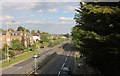
3
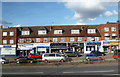
Mowbray Parade
Suburban shops facing the A41 which is still called Watford By-Pass along here from pre M1 days.
Image: © Des Blenkinsopp
Taken: 24 Oct 2013
0.18 miles
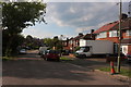
5
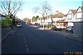
Edgware: Glendale Avenue
Viewed looking north westwards.
Image: © Nigel Cox
Taken: 17 Dec 2005
0.20 miles
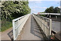
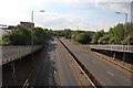
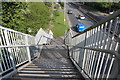
7
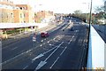
Edgware: A41 Edgware Way
Viewed looking eastwards from the Edgwarebury Lane footbridge.
Image: © Nigel Cox
Taken: 17 Dec 2005
0.21 miles