IMAGES TAKEN NEAR TO
Stream Lane, EDGWARE, HA8 7YA
Introduction
This page details the photographs taken nearby to Stream Lane, HA8 7YA by members of the Geograph project.
The Geograph project started in 2005 with the aim of publishing, organising and preserving representative images for every square kilometre of Great Britain, Ireland and the Isle of Man.

There are currently over 7.5m images from over14,400 individuals and you can help contribute to the project by visiting https://www.geograph.org.uk
Image Map
Images are licensed for reuse under creativecommons.org/licenses/by-sa/2.0
Notes
- Clicking on the map will re-center to the selected point.
- The higher the marker number, the further away the image location is from the centre of the postcode.
Image Listing (169 Images Found)
Images are licensed for reuse under creativecommons.org/licenses/by-sa/2.0
Image
Details
Distance
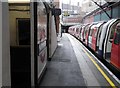
4
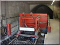
End of the Northern Line, Edgware tube station
An image of the bufferstops at Edgware tube station showing the tunnelmouth which was planned to accept tracks taking the line 5 kilometres northwest of this station to a new terminus at Bushey Heath. Construction on the new line to Bushey Heath began in the late 1930s but were halted by the outbreak of the Second World War. After the war, Green Belt legislation was introduced to limit the outward expansion of urban areas into the surrounding countryside. The area through which the new Bushey Heath extension was routed was designated as Green Belt meaning that the planned residential developments were prevented and the need for the stations serving them was removed. The completion of the plans to extend the Northern line were formally cancelled in 1950.
Image: © Oxyman
Taken: 26 Apr 2009
0.03 miles
5
End of the Northern Line, Edgware Underground Station
Image: © Robin Sones
Taken: 17 Sep 2014
0.03 miles
6
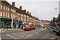
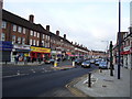
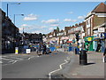
Station Road, Edgware
Looking down the hill towards the junction with Penshurst Gardens and Edgwarebury Lane. Shops with flats above dominate the street which becomes Hale Lane as it bends to the right in the distance.
Image: © Martin Addison
Taken: 6 Apr 2010
0.03 miles
7
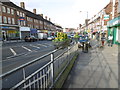
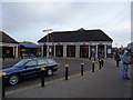
Station Road, Edgware
Just along from the Underground station, this is the main concentration of shops in Edgware.
Image: © Marathon
Taken: 25 Nov 2015
0.03 miles
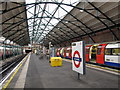
10
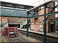
Edgware tube station - north end
LU's "New Works" programme in the mid-1930s included extending the Northern line northwards from Edgware to Bushey Heath via Brockley Hill and Elstree https://en.wikipedia.org/wiki/Edgware_tube_station . The line was never built, although some works were carried out including the partial boring of tunnels at the ends of platforms 2 and 3 at Edgware station to taken the tracks under Station Road.
Image: © Mike Quinn
Taken: 3 Oct 2018
0.04 miles