1
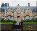
Edgware: Day's Almshouses, Watling Street
These almshouses were built by Charles Day in 1828. There are eight of them on a 1 acre plot fronting onto Watling Street at Stone Grove which he bought from All Souls College. During his lifetime Day selected the almspeople. By his will, he conveyed the almshouses and land to trustees, leaving sufficient money to provide an endowment of £100 a year for the upkeep of the property and weekly payments to the almspeople. In selecting almspeople the trustees were to give preference to parishioners of Edgware and Little Stanmore, providing that they did not sell or drink intoxicants, swear, or break the Sabbath. The almshouses consist of a long single-storied range in an early-19th-century Gothic style with steep gables, pinnacled buttresses and a slate roof. The front is faced with stone ashlar and has Gothic arcading below the eaves and verges. In the central gable, which is flanked by two smaller ones, is a clock and the date 1828.
Image: © Nigel Cox
Taken: 17 Dec 2005
0.01 miles
2
George V postbox on Stonegrove
Postbox HA8 706.
Image: © JThomas
Taken: 18 Mar 2017
0.02 miles
3
Houses on Stonegrove, Edgware
Image: © JThomas
Taken: 18 Mar 2017
0.03 miles
4
Information, Day's Almshouses, Stonegrove, Edgware
Image: © Robin Sones
Taken: 17 Sep 2014
0.04 miles
5
The Day's Almshouses, Stonegrove, Edgware
Image: © Robin Sones
Taken: 17 Sep 2014
0.05 miles
6
Day's Almshouses, Stonegrove, Edgware
Image: © Robin Sones
Taken: 17 Sep 2014
0.05 miles
7
Day's Almshouses, Edgware
A grade II listed building, dated 1828 above the central entrance.
Image: © Robin Webster
Taken: 14 Jun 2015
0.05 miles
8
Day's Almshouses, Edgware
Grade II listed building dated 1828. Architectural description at this https://historicengland.org.uk/listing/the-list/list-entry/1064820.
Image: © Jim Osley
Taken: 7 May 2016
0.05 miles
9
Day's Almshouses, Watling Street
The typical situation for earlier almshouses (which often date from the 17th century) is close to the parish church - often overlooking the churchyard. These are later - dated 1828 on the central gable, and flank a main thoroughfare. Pevsner describes them (in 'The Buildings of England: Middlesex') as 'cement-rendered . . . with cement barge-boarding'.
Photo taken late on a January afternoon,with rain threatening.
For earlier almshouses, in typical locations close to churches, see:
Image and
Image
Image: © Stefan Czapski
Taken: 27 Jan 2013
0.05 miles
10
Entrance, Stonegrove Park, Stonegrove. Edgware
Image: © Robin Sones
Taken: 17 Sep 2014
0.06 miles


