IMAGES TAKEN NEAR TO
Stonegrove Gardens, EDGWARE, HA8 7TE
Introduction
This page details the photographs taken nearby to Stonegrove Gardens, HA8 7TE by members of the Geograph project.
The Geograph project started in 2005 with the aim of publishing, organising and preserving representative images for every square kilometre of Great Britain, Ireland and the Isle of Man.

There are currently over 7.5m images from over14,400 individuals and you can help contribute to the project by visiting https://www.geograph.org.uk
Image Map
Images are licensed for reuse under creativecommons.org/licenses/by-sa/2.0
Notes
- Clicking on the map will re-center to the selected point.
- The higher the marker number, the further away the image location is from the centre of the postcode.
Image Listing (23 Images Found)
Images are licensed for reuse under creativecommons.org/licenses/by-sa/2.0
Image
Details
Distance
1
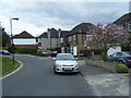
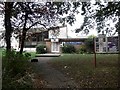
Pangbourne Drive
Looking along Pangbourne Drive from Jesmond Way.
Image: © DS Pugh
Taken: 31 Dec 2018
0.09 miles
2

Edgware and District Reformed Synagogue, Stonegrove
Image: © Robin Sones
Taken: 17 Sep 2014
0.11 miles
3
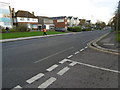
Stonegrove, Edgware
At the junction with Orchard Drive
Image: © Robin Sones
Taken: 17 Sep 2014
0.12 miles
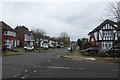
4
Along Pangbourne Drive
Approaching the junction with Dalkeith Grove.
Image: © DS Pugh
Taken: 31 Dec 2018
0.13 miles
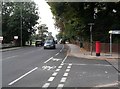
6
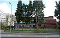
Edgware and District Reform Synagogue
Viewed from across Watling Street, the A5, at Stone Grove.
Image: © Jonathan Billinger
Taken: 8 Apr 2008
0.15 miles
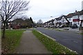
7
Stanmore: Dalkeith Grove
The 1940s Ordnance Survey mapping shows this whole area as a golf course. The road is viewed looking north eastwards with Lake Grove Recreation Ground beyond the railings on the right.
Image: © Nigel Cox
Taken: 17 Dec 2005
0.15 miles
8
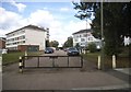
Flats on Lacey Drive, Edgware
As you can see, the road is closed to through traffic
Image: © David Howard
Taken: 9 Jul 2014
0.16 miles
9
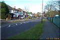
Watling Street, Edgware
This is Stone Grove in Edgware which is part of the A5 from London to Holyhead. The fact that the A5 runs almost dead straight from Marble Arch through Kilburn and Cricklewood to beyond Edgware makes it obvious it is following a Roman road - in this case Watling Street, which ran from Canterbury through London to Wroxeter. For more about the history of Watling Street see https://en.wikipedia.org/wiki/Watling_Street
Image: © Marathon
Taken: 25 Nov 2015
0.17 miles