IMAGES TAKEN NEAR TO
Lake View, EDGWARE, HA8 7RU
Introduction
This page details the photographs taken nearby to Lake View, HA8 7RU by members of the Geograph project.
The Geograph project started in 2005 with the aim of publishing, organising and preserving representative images for every square kilometre of Great Britain, Ireland and the Isle of Man.

There are currently over 7.5m images from over14,400 individuals and you can help contribute to the project by visiting https://www.geograph.org.uk
Image Map
Images are licensed for reuse under creativecommons.org/licenses/by-sa/2.0
Notes
- Clicking on the map will re-center to the selected point.
- The higher the marker number, the further away the image location is from the centre of the postcode.
Image Listing (39 Images Found)
Images are licensed for reuse under creativecommons.org/licenses/by-sa/2.0
Image
Details
Distance
1
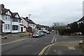
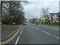
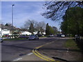
Lake View at Dukes Avenue
Looking along Lake View near the junction with Dukes Avenue in Edgware.
Image: © DS Pugh
Taken: 31 Dec 2018
0.02 miles
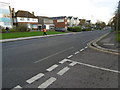
2
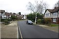
Dukes Avenue
Looking along Dukes Avenue in Edgware.
Image: © DS Pugh
Taken: 31 Dec 2018
0.06 miles
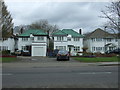
3
Watling Street, Edgware
This is Stone Grove in Edgware which is part of the A5 from London to Holyhead. The fact that the A5 runs almost dead straight from Marble Arch through Kilburn and Cricklewood to beyond Edgware makes it obvious it is following a Roman road - in this case Watling Street, which ran from Canterbury through London to Wroxeter. For more about the history of Watling Street see https://en.wikipedia.org/wiki/Watling_Street
Image: © Marathon
Taken: 25 Nov 2015
0.06 miles
4
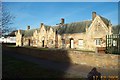
Edgware: Day's Almshouses, Watling Street
These almshouses were built by Charles Day in 1828. There are eight of them on a 1 acre plot fronting onto Watling Street at Stone Grove which he bought from All Souls College. During his lifetime Day selected the almspeople. By his will, he conveyed the almshouses and land to trustees, leaving sufficient money to provide an endowment of £100 a year for the upkeep of the property and weekly payments to the almspeople. In selecting almspeople the trustees were to give preference to parishioners of Edgware and Little Stanmore, providing that they did not sell or drink intoxicants, swear, or break the Sabbath. The almshouses consist of a long single-storied range in an early-19th-century Gothic style with steep gables, pinnacled buttresses and a slate roof. The front is faced with stone ashlar and has Gothic arcading below the eaves and verges. In the central gable, which is flanked by two smaller ones, is a clock and the date 1828.
Image: © Nigel Cox
Taken: 17 Dec 2005
0.07 miles
5
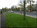
Stonegrove (A5), Edgware
Looking north west.
Image: © JThomas
Taken: 18 Mar 2017
0.07 miles
6
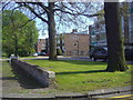
Coniston Court, Edgware
1960s flats built along Stonegrove
Image: © David Howard
Taken: 22 Apr 2010
0.07 miles
7
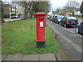
George V postbox on Stonegrove
Postbox HA8 706.
Image: © JThomas
Taken: 18 Mar 2017
0.08 miles
9
Stonegrove, Edgware
The A5 looking south
Image: © David Howard
Taken: 22 Apr 2010
0.10 miles
10
Watling Street, Edgware
This is Stone Grove in Edgware which is part of the A5 from London to Holyhead. The fact that the A5 runs almost dead straight from Marble Arch through Kilburn and Cricklewood to beyond Edgware makes it obvious it is following a Roman road - in this case Watling Street, which ran from Canterbury through London to Wroxeter. For more about the history of Watling Street see https://en.wikipedia.org/wiki/Watling_Street
Image: © Marathon
Taken: 25 Nov 2015
0.10 miles