IMAGES TAKEN NEAR TO
Approach Road, EDGWARE, HA8 7AN
Introduction
This page details the photographs taken nearby to Approach Road, HA8 7AN by members of the Geograph project.
The Geograph project started in 2005 with the aim of publishing, organising and preserving representative images for every square kilometre of Great Britain, Ireland and the Isle of Man.

There are currently over 7.5m images from over14,400 individuals and you can help contribute to the project by visiting https://www.geograph.org.uk
Image Map
Images are licensed for reuse under creativecommons.org/licenses/by-sa/2.0
Notes
- Clicking on the map will re-center to the selected point.
- The higher the marker number, the further away the image location is from the centre of the postcode.
Image Listing (174 Images Found)
Images are licensed for reuse under creativecommons.org/licenses/by-sa/2.0
Image
Details
Distance
2
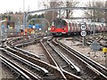
Tracks southeast of Edgware tube station
Image: © Mike Quinn
Taken: 14 Feb 2012
0.09 miles
3
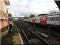
View from Edgware Underground station
The extension beyond Golders Green to Hendon and Edgware, delayed by the First World War, finally opened to Hendon Central in 1923 and on to Edgware on 18th August 1924. In 1933 it became part of the London Passenger Transport Board's Northern line as the Edgware branch.
In the London Passenger Transport Board's 'New Works Plan' of 1935 it was proposed that the line between what is now Finsbury Park and Edgware (LNER station) be taken over by the Northern line and be diverted into the new Underground station at Edgware. It was then proposed to extend the Northern line beyond Edgware to Bushey Heath. The service on the line from East Finchley to Edgware was suspended from 11th September 1939 to allow the work to be completed and the New Works Plan was expected to be completed by spring 1941. In the event the Northern line branch never got past Mill Hill East and the post war London Green Belt put paid to the Edgware to Bushey Heath extension, although evidence of both can still be seen. See http://www.disused-stations.org.uk/e/edgware/ and http://www.abandonedstations.org.uk/Northern_Heights_9.html and http://www.abandonedstations.org.uk/Northern_Heights_10.html
In this view the lines to the right head off to Burnt Oak, which is the next station, and those to the left go to the depot but once went towards East Finchley. There are two main depots on the Northern line. These are at Golders Green and Morden, and two smaller depots at Edgware and Highgate.
Image: © Marathon
Taken: 25 Nov 2015
0.09 miles

5
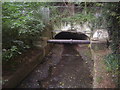
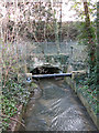
Dollis Brook going underneath the Northern Line
The brook was there first, the railway was built above it.
Image: © David Howard
Taken: 2 Oct 2013
0.10 miles
6
Culvert on Dean's Brook under the Tube Lines Edgware Track Depot
Image: © Mike Quinn
Taken: 26 Feb 2020
0.10 miles
7
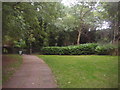
Path between Brook Avenue and West Way
The Northern Line railway to Edgware is on the right
Image: © David Howard
Taken: 2 Oct 2013
0.10 miles
8
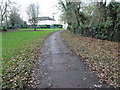
Short cut to Edgware station
This path gives people living in the West Way and Dean's Lane area a short cut to Edgware station and the neighbouring shops. It crosses Dean's Brook here which is a tributary of the Silk Stream which in turn meets the River Brent at the Brent Reservoir.
Image: © Marathon
Taken: 25 Nov 2015
0.10 miles
9
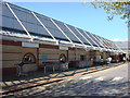
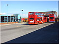
Broadwalk Shopping Centre, Edgware
As seen from Edgware Bus Station.
The buses head from Station road around the long thin bus station before returning to Station Road.
Shoppers can head to Marks and Spencers and the rest of the shopping centre.
Image: © David Anstiss
Taken: 27 Jan 2013
0.11 miles
10
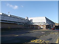
Bus station, Edgware
Located between Edgware tube station and the Broadwalk Shopping Centre.
Image: © Oxyman
Taken: 26 Apr 2009
0.11 miles