IMAGES TAKEN NEAR TO
Howberry Road, EDGWARE, HA8 6TB
Introduction
This page details the photographs taken nearby to Howberry Road, HA8 6TB by members of the Geograph project.
The Geograph project started in 2005 with the aim of publishing, organising and preserving representative images for every square kilometre of Great Britain, Ireland and the Isle of Man.

There are currently over 7.5m images from over14,400 individuals and you can help contribute to the project by visiting https://www.geograph.org.uk
Image Map
Images are licensed for reuse under creativecommons.org/licenses/by-sa/2.0
Notes
- Clicking on the map will re-center to the selected point.
- The higher the marker number, the further away the image location is from the centre of the postcode.
Image Listing (58 Images Found)
Images are licensed for reuse under creativecommons.org/licenses/by-sa/2.0
Image
Details
Distance

2
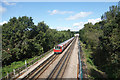
Jubilee Line at Canons Park
London Underground Jubilee Line train between Canons Park station and the terminus at Stanmore.
Image: © Des Blenkinsopp
Taken: 4 Sep 2019
0.09 miles
3
Cloyster Wood, Stanmore
A short residential street. Named after what was here before perhaps?
Image: © Des Blenkinsopp
Taken: 4 Sep 2019
0.09 miles
4
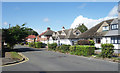
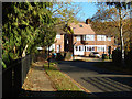
Cheyneys Avenue, Stanmore
Semi-detached houses line the eastern side of Cheyneys Avenue. Not unusually nowadays, many of the front gardens have been paved over as car parks.
Image: © Stephen McKay
Taken: 25 Nov 2016
0.10 miles
5
A Tree, Cloyster Wood
Cloyster Wood isn't a clump of trees, it's the name of the road on the left. It meets Cheyneys Avenue at this sort of half roundabout.
Image: © Des Blenkinsopp
Taken: 4 Sep 2019
0.10 miles
6
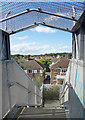
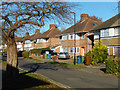
View from a Footbridge
Housing in Cheyneys Avenue and beyond seen from a bridge over the railway.
Image: © Des Blenkinsopp
Taken: 4 Sep 2019
0.12 miles
7
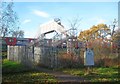
Canons Park: Cheyneys Avenue footbridge over the Jubilee Line
A right of way existed here long before the railway came or the park was opened to the public, hence the existence of the footbridge today. This is between Canons Park and Stanmore stations. As can be seen the decking of the footbridge is a lot higher than the roof of a standard Jubilee Line train, suggesting that rolling stock with higher roofs was used at one time, or occasionally now, or might be in the future.
Image: © Nigel Cox
Taken: 14 Nov 2018
0.12 miles
8
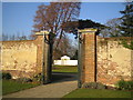
Canons Park: The Temple
Viewed through the northern entrance gates to The George V Memorial Garden Image the Temple dates from the early 1800s and is a listed structure that originally had a palm house at its front. After suffering vandalism and a fire it has recently been completely refurbished by Harrow Council, the remedial works having been funded by part of a £1 million grant from the Heritage Lottery Fund to the overall restoration of Canons Park.
Image: © Nigel Cox
Taken: 21 Dec 2007
0.13 miles
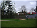
10
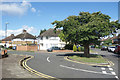
Cheyneys Avenue, Stanmore
Cheyneys Avenue takes a 90 degree turn to the right with part of Canons Park on the left and the railway behind the houses.
Image: © Stephen McKay
Taken: 25 Nov 2016
0.14 miles