IMAGES TAKEN NEAR TO
Cheyneys Avenue, EDGWARE, HA8 6SA
Introduction
This page details the photographs taken nearby to Cheyneys Avenue, HA8 6SA by members of the Geograph project.
The Geograph project started in 2005 with the aim of publishing, organising and preserving representative images for every square kilometre of Great Britain, Ireland and the Isle of Man.

There are currently over 7.5m images from over14,400 individuals and you can help contribute to the project by visiting https://www.geograph.org.uk
Image Map
Images are licensed for reuse under creativecommons.org/licenses/by-sa/2.0
Notes
- Clicking on the map will re-center to the selected point.
- The higher the marker number, the further away the image location is from the centre of the postcode.
Image Listing (87 Images Found)
Images are licensed for reuse under creativecommons.org/licenses/by-sa/2.0
Image
Details
Distance
1
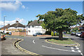
A Tree, Cloyster Wood
Cloyster Wood isn't a clump of trees, it's the name of the road on the left. It meets Cheyneys Avenue at this sort of half roundabout.
Image: © Des Blenkinsopp
Taken: 4 Sep 2019
0.07 miles
3
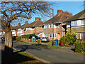
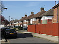
Cheyneys Avenue, Stanmore
Semi-detached houses line the eastern side of Cheyneys Avenue. Not unusually nowadays, many of the front gardens have been paved over as car parks.
Image: © Stephen McKay
Taken: 25 Nov 2016
0.08 miles
5
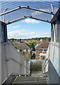
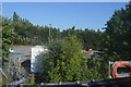
View from a Footbridge
Housing in Cheyneys Avenue and beyond seen from a bridge over the railway.
Image: © Des Blenkinsopp
Taken: 4 Sep 2019
0.09 miles
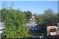
6
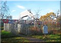
Canons Park: Cheyneys Avenue footbridge over the Jubilee Line
A right of way existed here long before the railway came or the park was opened to the public, hence the existence of the footbridge today. This is between Canons Park and Stanmore stations. As can be seen the decking of the footbridge is a lot higher than the roof of a standard Jubilee Line train, suggesting that rolling stock with higher roofs was used at one time, or occasionally now, or might be in the future.
Image: © Nigel Cox
Taken: 14 Nov 2018
0.09 miles
7
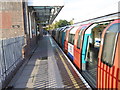
Underground train waiting at Canons Park station
The branch between Wembley Park and Stanmore was opened by the Metropolitan Railway in 1932. It was much harder to construct than anticipated and amongst the heavy works was the diversion of the Wealdstone Brook. Canons Park station opened on the same day as the line, 10th December 1932. It became part of the Bakerloo Line in 1939 when that line was extended from Baker Street to Finchley Road, from there taking over the Metropolitan's old slow tracks to Wembley Park before the Bakerloo continued to Stanmore. In 1979 it became part of the Jubilee Line to Charing Cross, and in 1999 was linked to Stratford by the Jubilee Line Extension.
A down Jubilee line train is about to set off for its final destination at Stanmore.
Image: © Marathon
Taken: 28 Oct 2015
0.09 miles
8
Canons Park station, southbound platform
Image: © Robin Webster
Taken: 23 Feb 2013
0.09 miles
10
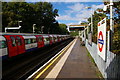
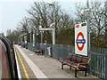
Canons Park underground station, looking towards Stanmore
Image: © Christopher Hilton
Taken: 22 Sep 2016
0.10 miles