IMAGES TAKEN NEAR TO
Roch Avenue, EDGWARE, HA8 6DW
Introduction
This page details the photographs taken nearby to Roch Avenue, HA8 6DW by members of the Geograph project.
The Geograph project started in 2005 with the aim of publishing, organising and preserving representative images for every square kilometre of Great Britain, Ireland and the Isle of Man.

There are currently over 7.5m images from over14,400 individuals and you can help contribute to the project by visiting https://www.geograph.org.uk
Image Map
Images are licensed for reuse under creativecommons.org/licenses/by-sa/2.0
Notes
- Clicking on the map will re-center to the selected point.
- The higher the marker number, the further away the image location is from the centre of the postcode.
Image Listing (18 Images Found)
Images are licensed for reuse under creativecommons.org/licenses/by-sa/2.0
Image
Details
Distance
1
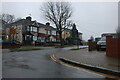
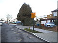
Shaldon Road at the junction of Bridgewater Gardens
Canons High School is on the right
Image: © David Howard
Taken: 13 Jan 2021
0.09 miles
3
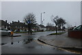
Camrose Avenue at the corner of Shaldon Road
Image: © David Howard
Taken: 13 Jan 2021
0.14 miles
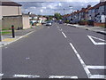
5
Bridgewater Gardens, Edgware
At the entrance to Canons High School
Image: © David Howard
Taken: 28 Jan 2015
0.15 miles
7
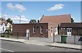
Camrose Baptist Church Hall
On the corner of Camrose Avenue and Haverford Way. The church is the pitched roof building beyond.
The church's website says this :- "The building, that is now the main church, was originally planned to be the church hall, and building work started on 27 July 1935, and the cost of the project was £3800. The building was opened on 22 February 1936.
An extension - our current hall, lounge and kitchen - was completed in September 1976."
Image: © Des Blenkinsopp
Taken: 4 Sep 2019
0.20 miles
8
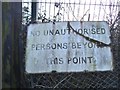
Old sign at the end of St Davids Drive, Edgware
This is a lesson for sign detectives. Firstly, it is not a road sign as they do not apply to persons but pedestrians when not referring to vehicles. It appears to be in the style of pre-Worboys from a distance, but being confirmed by the wording as privately made (this is the private rear entrance to the playing fields used for football training, and now The Hive, temporary home of Barnet FC) the letters are a random font chosen by the signmakers, stuck on, and proven unofficial as the three bars on the capital E are equal, while pre-Worboys had a shorter one in the middle. The R is also totally different with a long tail, and may well have been made as recently as the 80s and is just badly weathered and badly made.
Image: © David Howard
Taken: 28 Jan 2015
0.20 miles
9
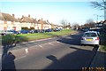
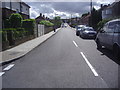
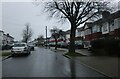
Edgware: Camrose Avenue
Viewed looking north eastwards from the junction with Turner Road.
Image: © Nigel Cox
Taken: 17 Dec 2005
0.20 miles
10
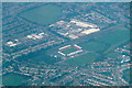
The Hive, Barnet FC, from the air
The ground is actually just outside the Borough of Barnet.
Image: © Mike Pennington
Taken: 31 Aug 2018
0.20 miles