IMAGES TAKEN NEAR TO
Broomgrove Gardens, EDGWARE, HA8 5SH
Introduction
This page details the photographs taken nearby to Broomgrove Gardens, HA8 5SH by members of the Geograph project.
The Geograph project started in 2005 with the aim of publishing, organising and preserving representative images for every square kilometre of Great Britain, Ireland and the Isle of Man.

There are currently over 7.5m images from over14,400 individuals and you can help contribute to the project by visiting https://www.geograph.org.uk
Image Map
Images are licensed for reuse under creativecommons.org/licenses/by-sa/2.0
Notes
- Clicking on the map will re-center to the selected point.
- The higher the marker number, the further away the image location is from the centre of the postcode.
Image Listing (7 Images Found)
Images are licensed for reuse under creativecommons.org/licenses/by-sa/2.0
Image
Details
Distance
1
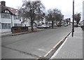
Orchard Grove, Edgware
Row upon row of 1950's suburbia.
Image: © Jonathan Billinger
Taken: 8 Apr 2008
0.09 miles
3
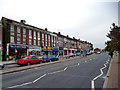
Queensbury: Mollison Way
Shops on the north side, looking east.
Image: © Dr Neil Clifton
Taken: 30 Oct 2015
0.22 miles
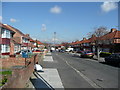
4
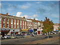
Parade of shops in Mollison Way, Edgware
This is the parade of shops in Mollison Way where the road widens to briefly become a dual carriageway.
Image: © Marathon
Taken: 28 Oct 2015
0.23 miles
5
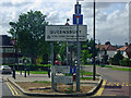
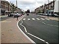
Welcome to Queensbury
Queensbury was originally Little Stanmore, but with the arrival of the railway a new name was needed to avoid confusion with Stanmore, and a competition was held. The winner simply used the alternative to the adjacent Kingsbury and there it was. It is divided between Brent and Harrow boroughs which make half a suburb of Edgware (HA8) and half Stanmore (HA7).
Image: © David Howard
Taken: 16 May 2009
0.24 miles