IMAGES TAKEN NEAR TO
Orchard Grove, EDGWARE, HA8 5BH
Introduction
This page details the photographs taken nearby to Orchard Grove, HA8 5BH by members of the Geograph project.
The Geograph project started in 2005 with the aim of publishing, organising and preserving representative images for every square kilometre of Great Britain, Ireland and the Isle of Man.

There are currently over 7.5m images from over14,400 individuals and you can help contribute to the project by visiting https://www.geograph.org.uk
Image Map
Images are licensed for reuse under creativecommons.org/licenses/by-sa/2.0
Notes
- Clicking on the map will re-center to the selected point.
- The higher the marker number, the further away the image location is from the centre of the postcode.
Image Listing (21 Images Found)
Images are licensed for reuse under creativecommons.org/licenses/by-sa/2.0
Image
Details
Distance
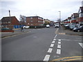
1
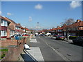
Orchard Grove, Edgware
Row upon row of 1950's suburbia.
Image: © Jonathan Billinger
Taken: 8 Apr 2008
0.03 miles
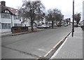
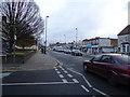
5
Vancouver Road, Burnt Oak
A nice example of a dog leg junction.
Image: © David Howard
Taken: 12 Nov 2015
0.20 miles
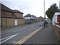
7
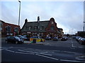
The Lansdowne public house, Burnt Oak Broadway
Image: © Stacey Harris
Taken: 27 Nov 2010
0.20 miles
8
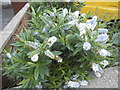
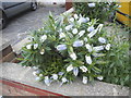
Garden flowers on The Chase, Burnt Oak
I don't remember seeing any like these before, they were blue and white on different flowers.
Image: © David Howard
Taken: 12 Nov 2015
0.21 miles
9
Garden flowers on The Chase, Burnt Oak
Image: © David Howard
Taken: 12 Nov 2015
0.21 miles
10
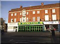
Mama Cass Cafeteria on Burnt Oak Broadway
Image: © David Howard
Taken: 4 Feb 2016
0.22 miles