IMAGES TAKEN NEAR TO
Albany Crescent, EDGWARE, HA8 5AL
Introduction
This page details the photographs taken nearby to Albany Crescent, HA8 5AL by members of the Geograph project.
The Geograph project started in 2005 with the aim of publishing, organising and preserving representative images for every square kilometre of Great Britain, Ireland and the Isle of Man.

There are currently over 7.5m images from over14,400 individuals and you can help contribute to the project by visiting https://www.geograph.org.uk
Image Map
Images are licensed for reuse under creativecommons.org/licenses/by-sa/2.0
Notes
- Clicking on the map will re-center to the selected point.
- The higher the marker number, the further away the image location is from the centre of the postcode.
Image Listing (64 Images Found)
Images are licensed for reuse under creativecommons.org/licenses/by-sa/2.0
Image
Details
Distance
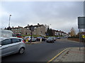
3
Burnt Oak Broadway (A5)
Looking north west.
Image: © JThomas
Taken: 18 Mar 2017
0.05 miles
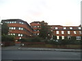
4
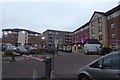
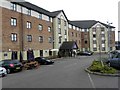
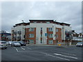
Edgware Premier Inn
Looking towards the large hotel on Zodiac Close in Edgware.
Image: © DS Pugh
Taken: 31 Dec 2018
0.06 miles
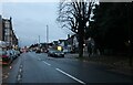
5
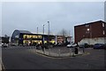
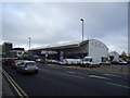
Peugeot dealership
Looking along Zodiac Close and across Burnt Oak Broadway towards a car showroom. The car park is overflow parking for the Premier Inn.
Image: © DS Pugh
Taken: 31 Dec 2018
0.06 miles
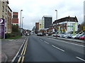
7
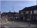
Junction of Whitchurch Lane and High Street Edgware
Image: © David Howard
Taken: 22 Apr 2010
0.07 miles
9
Robins and Day Peugeot, Edgware
Formerly Warwick Wright
Image: © Stacey Harris
Taken: 27 Nov 2010
0.09 miles