IMAGES TAKEN NEAR TO
Cressingham Road, EDGWARE, HA8 0RP
Introduction
This page details the photographs taken nearby to Cressingham Road, HA8 0RP by members of the Geograph project.
The Geograph project started in 2005 with the aim of publishing, organising and preserving representative images for every square kilometre of Great Britain, Ireland and the Isle of Man.

There are currently over 7.5m images from over14,400 individuals and you can help contribute to the project by visiting https://www.geograph.org.uk
Image Map (Loading...)


Getting Data...Please wait
Leaflet Map data © OpenStreetMap
Images are licensed for reuse under creativecommons.org/licenses/by-sa/2.0
Notes
- Clicking on the map will re-center to the selected point.
- The higher the marker number, the further away the image location is from the centre of the postcode.
Image Listing (30 Images Found)
Images are licensed for reuse under creativecommons.org/licenses/by-sa/2.0
Image
Details
Distance
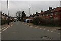
2
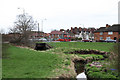
Towards Cressingham Road
Looking across Watling Park.
Image: © DS Pugh
Taken: 31 Dec 2018
0.12 miles
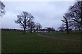
3
Abbots Road
Looking along the road beside Watling Park.
Image: © DS Pugh
Taken: 31 Dec 2018
0.14 miles
4
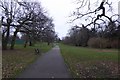
Path leading to Watling Avenue
A path leading across Watling Park.
Image: © DS Pugh
Taken: 31 Dec 2018
0.15 miles
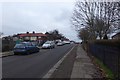
5
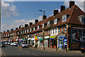
Burnt Oak: parade of shops on Deansbrook Road
Image: © Christopher Hilton
Taken: 19 Apr 2017
0.16 miles
6
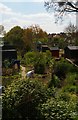
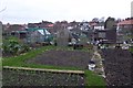
Allotments beside Abbots Road
Looking through a wire fence into the allotments.
Image: © DS Pugh
Taken: 31 Dec 2018
0.17 miles
7
Burnt Oak: the Silk Stream flowing through allotments
Image: © Christopher Hilton
Taken: 19 Apr 2017
0.17 miles
8
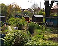
Burnt Oak: the Silk Stream flowing through allotments
Image: © Christopher Hilton
Taken: 19 Apr 2017
0.17 miles
9
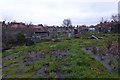
Allotments between Abbots Road and Deansbrook Road
Looking towards Langham Gardens.
Image: © DS Pugh
Taken: 31 Dec 2018
0.17 miles
10
Burnt Oak Brook
Looking at the point where it passes under Deansbrook Road. A 303 bus makes its way along the road on route to Asda's in Colindale from Edgware. In London terms this is a young route, only commencing in 1992.
The Burnt Oak Brook has its source in Simmonds Mead. Its route through Mill Hill Broadway is contained in a culvert but it surfaces in Lyndhurst Park to pass through Burnt Oak on its way to join the Silk Stream, eventually flowing into The Welsh Harp in West Hendon.
Image: © Martin Addison
Taken: 25 Feb 2011
0.19 miles